RockWorks utilizes a variety of different reference tables and libraries to perform many of its routine tasks, from plotting symbols on maps and patterns on cross sections, to looking up lithology types and polygon vertices.
You can access the reference tables and libraries using the Project Manager tab in the main program window.
! Tip: all of the main program tabs are dockable if you like to have the Project Manager nestled next to the Borehole Manager or the Datasheet.
! This topic discusses the accessory or "look-up" tables in your project. For information about the borehole data tables, where you actually enter your downhole measurements/rock types/etc., see Entering Your Borehole Data.
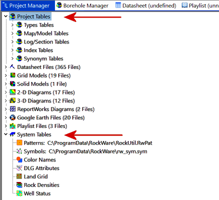
The reference tables will be listed under two main headings in the Project Manager. To view the individual tables, just expand the heading and sub-heading, and double-click on any of the listed tables to view the table's contents and make any changes. You can click on the links below to access more information about the specific tables.
Project Tables: Stored in the project database (.sqlite). Locate these at the top of the Project Manager pane.
Types Tables These define material types for the project (lithology, stratigraphy, etc.) and column headings for certain data tables. Only one table of each type is defined. Aquifer Names
Lists aquifer names and the patterns and colors to be used to represent them in diagrams. (More info) Bitmap Types
Lists borehole image categories. (More info) Litho Types
Lists lithologic "keywords" and the patterns, colors, and other values to be associated with them, for lithologic logs and models (blocks, profiles, sections, fence diagrams, etc.). (More info) Strata Types
Lists stratigraphic formation names and the patterns, colors, formation order, and other values to be associated with them, for strip logs, surface maps, fence diagrams, models, etc. (More info) I-Data Types
Defines the column titles for the I-Data table. (More info) Defines the column titles for the I-Text table. (More info) Defines the column titles for the T-Data table. (More info) P-Data Types
Defines the column titles for the P-Data table. (More info) Defines the column titles for the P-Text table. (More info) Const Types
Lists materials used in well construction columns in strip logs. They define material names, and the patterns and colors to be used to represent them in log diagrams. (More info)
Map/Model Tables Define custom settings for maps and models. Multiple versions of these tables are allowed. Color Fill Table
Defines numeric value ranges and the colors to be used to represent them in 2D and 3D color-filled contour maps and 3D solid model diagrams for which you've requested "Custom" color intervals. (More info) Contour Table
Defines a listing of Z-values and their corresponding line styles and (optionally) contour labels, to be used by the program when building 2D line contour maps for which you have requested "Custom" intervals. (More info) Vector Symbol Range Table
Defines the size and color of symbols displayed on a 2D point map, based on a measured value at that sample location, to create proportional symbol maps (also called "bubble maps"). (More info) Color Point Map Range Table
Defines the size and color of the spheres or cubes, based on a measured value at that sample location, to be displayed on a 3D point map for which you've requested "table-based" symbols. (More info) RockWorks17 Fault Table
Used in earlier versions of RockWorks to store 2D fault locations. Can be imported into the new Faults tab. (More info) Polygon Table
Lists a series of X (Easting) and Y (Northing) coordinates that identify the boundary vertices of a polygonal area, used to filter grid models and solid models. (More info) Polygon List Table
Contains a list of Polygon Table names for advanced polygon filtering. 3D IDW Sector Table
Defines the 3D search sectors for the Table-Based Inverse-Distance solid modeling algorithm. (More info) 2D IDW Sector Table
Defines the 2D search sectors for the Table-Based Inverse-Distance gridding algorithm. (More info)
Log/Section Tables Define section, profile, and fence locations, and bargraph scaling for logs. Multiple versions of these tables are allowed. XY Coordinates Table
Lists a series of X,Y coordinate locations to be used to define the panel endpoints in a RockWorks cross section diagram, if the interactive section-picking map is not to be used. (More info) XY Pair Table
Lists a series of X,Y coordinate pairs to be used to define the panel endpoints in a RockWorks fence diagram, if the interactive fence-picking map is not to be used. (More info) Profile Table
Lists two X,Y coordinate locations to be used to define the panel endpoints in a RockWorks projected profile diagram, if the interactive profile-picking map is not to be used. (More info) Bargraph Scale Table
Defines the bargraph size for 2D and 3D striplogs, based on measured values. (More info)
Index Tables These are used to create customized legends for 2D diagrams. Multiple versions of these tables are allowed. Color Index Table
Used to generate a custom color legend inside a map/diagram legend box in RockPlot2D. (More info) Line Style Index Table
Used to create a customized legend showing specific line styles and captions inside a map/diagram legend box in RockPlot2D. (More info) Pattern Index Table
Used to generate a customized legend showing specific pattern designs and captions inside a map/diagram legend box in RockPlot2D. (More info) Symbol Index Table
Used to create a customized legend showing specific symbol designs and captions inside a map/diagram legend box in RockPlot2D. (More info)
Synonym Table
A substitution table used by the Datasheet | Edit | Columns | Translate utility. (More info)
System Tables: These are tables that aren't project-specific and are stored in the RockWorks System folder. You can locate these at the bottom of the Project Manager program tab.
Patterns
The Pattern Table contains the RockWare pattern library, containing the graphic pattern designs used in logs, cross sections, and geology maps (Borehole Manager), lease maps (Utilities). (More info) Symbols
The Symbol Table contains the RockWare symbol library, containing graphic symbol designs used in maps and diagrams. The symbols can be displayed in the RockWorks datasheet and in the Borehole Manager Location and Symbols tables. (More info) Color Names
This table lists color names, in "regular" language (such as "dark brown" or "10YR 3/6" Munsell codes) and their color equivalents. These can be used to associate rock descriptions with Windows colors in the Colors database table.(More info) DLG Attributes
Used by RockPlot2D to know how to plot different Digital Line Graph entities (roads vs. rivers, etc.). (More info) Rock Densities
Used as a reference table for determining the densities of various rock types. (More info) Well Status
Used by the Tobin, KGS, and IHS import utilities, and the symbol update tool, to make a association between well status and well symbol. (More info)
Managing Project Look-up Tables
![]()