A "2D DW Sector Table" is used to define one or more 2D regions within which the Inverse-Distance Directional Weighting gridding method will look for points as it's assigning a node value, and apply the user-defined modeling settings.
! You can store multiple 2D IDW sector tables in your project database. If you assign detailed names they'll be easy to distinguish when you're selecting which to use. 2D IDW sector tables can be accessed in the Project Manger program tab, under the Project Tables | Map/Model Tables grouping.
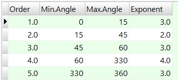
- Order: The values are assigned automatically as you edit the table. You can edit the Order values to re-order the rows.
- Min Angle, Max Angle: These columns define the minimum and maximum azimuth bearing (0 to 360) from each grid node to be searched for points.
- Exponent: Enter the Inverse-Distance weighting exponent to apply to control points that lie within this bearing range from the grid node being interpolated.
- You may list as many 2D sector-exponent associations as you wish.
- Any directions that you don't define here will be assigned the default exponent you've defined in the gridding options window. This can be handy - just list here specific weighting direction(s) and exponent(s), and leave any others undefined so that the default will be used.

RockWare home page