RockPlot2D (the RockWorks plotting program) offers import of USGS Digital Line Graph ("DLG") data extracted from 1:100,000 or 1:2,000,000-scale maps, Optional format. Boundary, transportation, hydrography, hypsography (contour) and land grid categories are supported. The SDTS format is not currently supported.
In order to know how to plot the different DLG entities (roads vs. rivers, etc.), the program uses the information stored in the "DLG Attribute Table." This Table lists different DLG entity types, plus the line style, thickness, and color to be used to plot them.
The DLG Attributes table is stored in a text file "DLG Attributes.tab", installed into the program's System folder. Since this is a system-level table, only one version of this table is permitted. You can access the DLG Attributes via the Project Manger program tab, under the System Tables grouping.
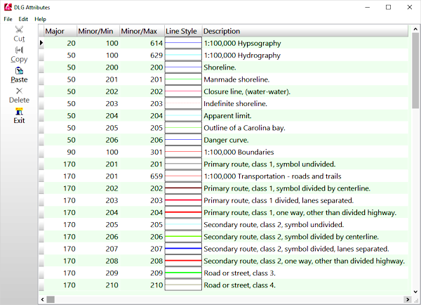
- Columns:
- Major: This column lists the major code for the DLG element. Within a DLG data file, like items will have the same major code, with minor codes differentiating specifics.
- Minor/Min, Minor/Max: These columns contain the minor attribute range for the listed item.
- Line Style: Double-click here to select a line style, thickness, and color for the indicated DLG entity.
- Description: This last column contains a description for the listed attribute. These may be any length and are used for your own information only.
- There are many different kinds of items that can be listed in a DLG file, and these are organized into groups based on like characteristics (roads vs. coastlines vs. railroads, etc.). Within these "major" groupings, there are "minor" groupings (undivided highways vs. divided highways, etc.). Both the major and minor groupings have numeric labels.
- If you wish to change any of the entries, to change the way they are plotted when imported into RockPlot2D, please note:
- Each row in the data file represents a single DLG file component, and each column contains information about that item.
- No blank rows are permitted in the listing.

RockWare home page