Borehole Data Blocks
Types Tables
Misc Project Tables
Project Dimensions
General notes:
- Columns must be separated by Tab characters.
Borehole Data Blocks
Well Locations Block
This data block is required.
<LOCATIONS>
Bore Easting Northing Elev Collar TD Long Lat Sym Clr
DH-1 1505.00 54535.12 4543.4 4543.4 202 -125.3423 44.53234 255 0
DH-2 2102.23 43453.43 4654.8 4654.8 210 -125.2334 45.48394 121 0
DH-3 3245.25 32342.12 4021.6 4021.6 157 -125.6543 44.53245 44 453
</LOCATIONS>
Notes:
- The columns may be listed in any order. During import, RockWorks will look for column headings to know how to match your text columns with the database fields.
- The heading line is required. The spelling of the heading labels is not important, however if you use the "expected" spelling shown above, the field mapping will occur automatically during import. If you use different spelling in the column headings, you'll need to manually map the fields. For example, a column labeled "Elevation" would be mapped automatically to the database "Elevation" field, but a column labeled "Elev" would need to be mapped manually.
- The following fields (columns) are required:
- Borehole Name, shown above in the "Bore" column
- Easting
- Northing
- Surface elevation, shown in the "Elevation" column
- Collar elevation.
- Total depth, shown in the "TD" column
- Symbol numbers refer to the index numbers in the current RockWorks symbol table. You can leave this blank, and the program will just assign a default symbol design.
- The color numbers refer to the very large color palette in Windows. If you aren’t sure what to enter, you can leave it blank and the program will assign black. If you do wish to specify specific colors, see Color Codes (below).
- Comments can be included. They can include descriptive text that will be imported into the Location tabs' Comments window.
- You can also include columns for data that you wish to map into any customized fields you've created in the Location table.
See also: Entering well locations
 Back to main topic
Downhole Survey Data Block
Optional.
Example:
<ORIENTATION>
Bore Depth Azimuth Inclination
DH-2 0.00 90.00 -90.00
DH-3 0.00 135.00 -45.00
DH-7 0.00 270.00 -90.00
</ORIENTATION>
Notes:
- Use this data block to define the downhole survey for inclined and/or deviated boreholes. This information will be posted to the Borehole Manager Orientation table.
- The heading line is required.
- The order of the columns must comply with the format as shown, but the spelling of the heading labels themselves is not important.
- Column 1 lists the name of the borehole for which the orientation data is being entered. If the boreholes don't already exist in the RockWorks database, be sure that the boreholes listed are referenced in the Locations block.
- Column 2 lists the depth at which the survey measurement was taken.
- Column 3 lists the bearing (in 0 – 360 degrees azimuth, with 0 = north) of the well at this depth.
- Column 4 lists the inclination of the well at this depth, where zero is horizontal, -90 is vertical downward, and +90 is vertical upward.
See also: Entering Well Orientation Data
Back to main topic
Lithology Data Block
Optional.
Example:
<LITHOLOGY>
Bore Depth-1 Depth-2 Lithology
DH-1 0.00 1.00 Crud
DH-1 1.00 2.60 Concrete
DH-1 2.60 3.00 Limestone
DH-2 0.00 1.30 Crud
DH-2 1.30 2.10 Concrete
DH-2 2.10 3.50 Limestone
</LITHOLOGY>
Notes:
- Use this block to define the lithology depth intervals and keywords for all boreholes. This data will be imported into the Borehole Manager Lithology table.
- The heading line is required.
- The order of the columns must comply with the format as shown, but the spelling of the heading labels themselves is not important
- Columns must be separated by Tab characters.
- Column 1 lists the name of the borehole for which the lithology data is being entered. If the boreholes don't already exist in the RockWorks database, be sure that the boreholes listed are referenced in the LOCATIONS block.
- Be sure that the data is sorted on Column 1 (e.g. all rows for each borehole grouped together) - the import tool uses grouped ID's to know when the lithology data for each well begins and ends.
- Columns 2 and 3 list the depth to the top of the interval and the depth to the base of the interval being described.
- The 4th column lists the rock type or "keyword". The lithology keywords that you use should be referenced in the "Lith Type" block, or in a Lithology Types Table that already exists or that you modify after data import.
- The 5th column is optional and can contain description information that will be imported into the Description column of the Lithology tabs.
See also: Entering Lithology Data
Back to main topic
Stratigraphy Data Block
Optional.
Example:
<STRATIGRAPHY>
Bore Depth-1 Depth-2 Stratigraphy
DH-1 0.00 9.60 Vadose Zone
DH-1 9.60 11.10 Aquifer-1
DH-1 11.10 17.90 Aquitard-1
DH-2 0 10.8 Vadose Zone
DH-2 10.8 12.10 Aquifer-1
</STRATIGRAPHY>
Notes:
- Use this block to define the stratigraphic depth intervals and formation names for all boreholes. This data will be imported into the Borehole Manager Stratigraphy table.
- The heading line is required.
- The order of the columns must comply with the format as shown, but the spelling of the heading labels themselves is not important.
- Columns must be separated by Tab characters.
- Column 1 lists the name of the borehole for which the stratigraphy data is being entered. If the boreholes don't already exist in the RockWorks database, be sure that the boreholes listed are referenced in the LOCATIONS block.
- Be sure that the data is sorted on Column 1 (e.g. all rows for each borehole grouped together) - the import tool uses grouped ID's to know when the stratigraphy data for each well begins and ends.
- Columns 2 and 3 list the depth to the top of the interval and the depth to the base of the interval.
- The 4th column lists the formation name. The stratigraphic names that you use should be referenced in the Strat Type block or in a Stratigraphy Types Table that already exists or that you create after data import. RockWorks can build the Stratigraphy Types table on the fly during import, adding formations in the order in which they are listed in the import file; you should confirm formation order in the Types table after import is complete.
See also: Entering Stratigraphy Data, Missing Formations
Back to main topic
Well Construction Block
Optional.
Example:
<WELL CONSTRUCTION>
Bore Diam1 Diam2 Offset Depth1 Depth2 WellConstruction
DH-05 0.00 1.00 0.00 0.00 35.00 PVC Casing
DH-05 0.00 3.00 0.00 47.00 64.00 PVC Screen
DH-05 0.00 3.00 0.00 45.00 47.00 Sand
DH-05 1.00 3.00 0.00 32.00 45.00 Sand
DH-05 1.00 3.00 0.00 2.00 32.00 Bentonite
DH-05 1.00 3.00 0.00 0.00 2.00 Cement
</WELL CONSTRUCTION>
Notes:
- Use this block to list specific well construction materials, their diameter and the depth intervals in which they are to be displayed in logs. This data will be posted to the Borehole database Well Construction table.
- The heading line is required.
- The order of the columns must comply with the format as shown, but the spelling of the heading labels themselves is not important.
- Columns must be separated by Tab characters.
- Column 1 lists the name of the borehole for which the data is being entered. If the boreholes don't already exist in the RockWorks database, be sure that the boreholes listed are referenced in the LOCATIONS block.
- Be sure that the data is sorted on Column 1 (e.g. all information for each borehole grouped together) - the import tool uses grouped ID's to know when the well construction information for each well begins and ends.
- Columns 2 and 3 list the inner and outer diameter for the materials. This will determine the width of the pattern blocks in the log diagrams.
- Column 4 lists the offset from the center of the well that this material block is to be plotted, enabling multiple borings within a single construction diagram. Negative values offset the block to the left of the center, positive values to the right.
- Columns 5 and 6 list the depths to the top of the interval and the base of the interval for the material type.
- Column 7 lists the construction material type.
- The names that you use should be referenced in the Well Construction Types block (described below) or in a Well Construction Types Table that already exists or that you modify after data import.
See also: Entering Well Construction Data
Back to main topic
Interval Data Block
Optional.
Example:
<INTERVAL>
Bore Type Depth-1 Depth-2 Value
DH-1 Benzene 0.00 0.50 0.000
DH-2 Toluene 5.2 5.6 12.56
DH-4 PCB 11.50 12.00 0.180
</INTERVAL>
Notes:
- Use this block to list the quantitative data for all interval-measured downhole data for all boreholes. This data will be posted to the Borehole Manager I-Data (Intervals) table.
- The heading line is required.
- The order of the columns must comply with the format as shown, but the spelling of the heading labels themselves is not important.
- Columns must be separated by Tab characters.
- Column 1 lists the name of the borehole for which the data is being entered. If the boreholes don't already exist in the RockWorks database, be sure that the boreholes listed are referenced in the LOCATIONS block.
- Be sure that the data is sorted on Column 1 (e.g. all measurements for each borehole grouped together) - the import tool uses grouped ID's to know when the i-data for each well begins and ends.
- Column 2 lists the type of measurement you're entering, such as "Benzene" or "Toluene." These types must either already exist within the database or must be defined in the Interval Types block, described below. If you don't define them in advance, the program will do its best to define them on the fly, but you need to be sure to check their setup after import.
- Columns 3 and 4 list the depth to the top of the interval and the depth to the base of the interval for which the measurement was taken. If you have point-sampled data rather than interval-sampled data, see the Point Data block.
- Column 5 lists the real number value measured for the depth interval, for that components, for that borehole.
- RockWorks2004 utilized the <I-DATA> and </I-DATA> tags; these are also recognized.
See also: Entering Downhole Interval Data
Back to main topic
I-Text Block
Optional.
Example:
<ITEXT>
Bore Type Depth1 Depth2 Value
DH-1 Color 0 5 reddish-brown
DH-1 Color 20 25 grey and black
DH-1 Sample ID 0 5 DH1-A
DH-1 Sample ID 20 25 DH1-B
DH-3 Color 0 5 greenish-brown
DH-3 Sample ID 0 5 DH2-A
DH-3 Sample ID 20 25 DH2-B
</ITEXT>
Notes:
- Use this block to list alphanumeric data recorded for depth intervals downhole. This data will be posted to the Borehole Manager I-Text (Interval Text) table.
- The heading line is required.
- The order of the columns must comply with the format as shown, but the spelling of the heading labels themselves is not important.
- Columns must be separated by Tab characters.
- Column 1 lists the name of the borehole for which the data is being entered. If the boreholes don't already exist in the RockWorks database, be sure that the boreholes listed are referenced in the LOCATIONS block.
- Be sure that the data is sorted on Column 1 (e.g. all measurements for each borehole grouped together) - the import tool uses grouped ID's to know when the I-Text for each well begins and ends.
- Column 2 lists the type of measurement you're entering, such as "Color" or "Sample ID." These Types must either already exist within the database or must be defined in the I-Text Types block discussed below. If you don't define them in advance, the program will do its best to define them on the fly, but you need to be sure to check their setup after import.
- Columns 3 and 4 list the depth to the top of the interval and the depth to the base of the interval for which the information was recorded. If you have point-sampled text rather than interval-sampled, see the P-Text block.
- Column 5 lists the alphanumeric data recorded for the listed depth interval, for that borehole.
See also: Entering Downhole I-Text
Back to main topic
Time Interval Block
Optional.
Example:
<TMINTERVAL>
Bore Type Depth-1 Depth-2 Date Value
DH-1 TCE 25 30 2/14/2007 0.003
DH-1 TCE 25 30 4/15/2007 0.009
DH-1 PCB 25 30 2/14/2007 0.050
DH-1 PCB 25 30 4/15/2007 0.047
DH-2 TCE 34 39 2/15/2007 0.004
DH-2 TCE 34 39 4/16/2007 0.008
DH-2 PCB 34 39 2/15/2007 0.039
DH-3 TCE 18 23 2/15/2007 0.008
</TMINTERVAL>
Notes:
- Use this block to list the quantitative data for all date-based, interval-measured downhole data for all boreholes. This data will be posted to the Borehole Manager T-Data (Time Intervals) table.
- The heading line is required.
- The order of the columns must comply with the format as shown, but the spelling of the heading labels themselves is not important.
- Columns must be separated by Tab characters.
- Column 1 lists the name of the borehole for which the data is being entered. If the boreholes don't already exist in the RockWorks database, be sure that the boreholes listed are referenced in the LOCATIONS block.
- Be sure that the data is sorted on Column 1 (e.g. all measurements for each borehole grouped together) - the import tool uses grouped ID's to know when the T-data for each well begins and ends.
- Column 2 lists the type of measurement you're entering, such as "PCB" or "TCE." These types must either already exist within the database or must be defined in the T-Data Types block, described below. If you don't define them in advance, the program will do its best to define them on the fly, but you need to be sure to check their setup after import.
- Columns 3 and 4 list the depth to the top of the interval and the depth to the base of the interval for which the measurement was taken. If you have point-sampled data rather than interval-sampled data, see the P-Data block.
- Column 5 lists the date and (optionally) the time at which the measurement was taken.
- Column 6 lists the real number value measured for the depth interval, for that component, for that date, for that borehole.
See also: Entering Time-Based Interval Data
Back to main topic
Point Data Block
Optional.
Example:
<POINT>
Bore Type Depth Value
DH-1 Gamma 0 0.090
DH-1 Resistivity 1.0 0.240
DH-3 Neutron 23.40 0.240
</POINT>
Notes:
- Use this block to list the quantitative data for all point-measured downhole data for all boreholes. This data will be posted to the Borehole Manager P-Data (Points) table.
- The heading line is required.
- The order of the columns must comply with the format as shown, but the spelling of the heading labels themselves is not important.
- Columns must be separated by Tab characters.
- Column 1 lists the name of the borehole for which the data is being entered. If the boreholes don't already exist in the RockWorks database, be sure that the boreholes listed are referenced in the LOCATIONS block.
- Be sure that the data is sorted on Column 1 (e.g. all measurements for each borehole grouped together) - the import tool uses grouped ID's to know when the p-data for each well begins and ends.
- Column 2 lists the type of measurement you're entering, such as "Gamma" or "Resistivity." These Types must either already exist within the database or must be defined in the P-Data Types block discussed below. If you don't define them in advance, the program will do its best to define them on the fly, but you need to be sure to check their setup after import.
- Column 3 lists the depth at which the measurement was taken. If you have interval-sampled data rather than point-sampled data, see the Interval Data Block.
- Column 4 lists the real number value measured for the listed depth, for that borehole.
- RockWorks2004 utilized the <P-DATA> and </P-DATA> tags; these are also recognized.
See also: Entering Downhole Point Data
Back to main topic
P-Text Block
Optional.
Example:
<PTEXT>
Bore Type Depth Value
DH-1 Comment 23 Grades more clayey
DH-1 Comment 79.4 No data
DH-1 USCS 49 CL
DH-1 USCS 53 SP
DH-3 Comment 15 Grading to clay
DH-3 USCS 30 SC
DH-3 USCS 42 CL
</PTEXT>
Notes:
- Use this block to list the alphanumeric data recorded for depth points downhole. This data will be posted to the Borehole Manager P-Text (Point Text) table.
- The heading line is required.
- The order of the columns must comply with the format as shown, but the spelling of the heading labels themselves is not important.
- Columns must be separated by Tab characters.
- Column 1 lists the name of the borehole for which the data is being entered. If the boreholes don't already exist in the RockWorks database, be sure that the boreholes listed are referenced in the LOCATIONS block.
- Be sure that the data is sorted on Column 1 (e.g. all measurements for each borehole grouped together) - the import tool uses grouped ID's to know when the p-text for each well begins and ends.
- Column 2 lists the type of measurement you're entering, such as "Comments" or "USCS." These Types must either already exist within the database or must be defined in the P-Text Types block discussed below. If you don't define them in advance, the program will do its best to define them on the fly, but you need to be sure to check their setup after import.
- Column 3 lists the depth at which the information was recorded. If you have interval-sampled information rather than point-sampled, see the Interval Text block.
- Column 4 lists the alphanumeric information recorded for the listed depth, for that borehole.
See also: Entering Downhole P-Text Data
Back to main topic
Color Data Block
Optional
Example:
<ROCKCOLOR>
Bore Depth1 Depth2 Color Comment
DH-1 0.0 2.5 6190481 7.5YR 5/3
DH-1 2.5 8.0 10398657 5YR 7/2
DH-1 8.0 11.1 4087664 2.5Y 4/3
DH-2 0.0 1.7 5003643 2.5YR 4/3
</ROCKCOLOR>
Notes:
- Use this block to list the depths intervals, colors, and comments for all colors for all boreholes. This data will be posted to the Borehole Manager Colors datasheets.
- The heading line is required.
- The order of the columns must comply with the format as shown, but the spelling of the heading labels themselves is not important.
- Columns must be separated by Tab characters.
- Column 1 lists the name of the borehole for which the data is being entered. If the boreholes don't already exist in the RockWorks database, be sure that the boreholes listed are referenced in the LOCATIONS block.
- Be sure that the data is sorted on Column 1 (e.g. all measurements for each borehole grouped together) - the import tool uses grouped ID's to know when the color data for each well begins and ends.
- Columns 2 and 3 list the depth to the top of the interval and the depth to the base of the interval for which the color measurement was taken.
- In the 4th column, list the Windows color code. See Color Codes for an index to 16 main colors and for links to additional reference color programs. This column can be left blank if you wish to assign colors based on the comment field. (See importing colors for details.)
- Column 5 lists descriptive text for the color. This column is optional. This information can be used to assign the Windows colors automatically.
See also: Entering Color Data
Back to main topic
Fracture Data Block
Optional.
Example:
<FRACTURE>
Bore Depth Direction DipAngle Color Radius Aperture
DH-1 5.00 10.00 5.00 255 10.00 10.00
DH-2 15.00 45.00 10.00 255 10.00 1.00
</FRACTURE>
Notes:
- Use this block to list the fracture depths, bearings, dips, colors, radii, and aperture settings for all fractures for all boreholes. This data will be posted to the Borehole Manager Fractures tabs.
- The heading line is required.
- The order of the columns must comply with the format as shown, but the spelling of the heading labels themselves is not important.
- Columns must be separated by Tab characters.
- Column 1 lists the name of the borehole for which the data is being entered. If the boreholes don't already exist in the RockWorks database, be sure that the boreholes listed are referenced in the LOCATIONS block.
- Be sure that the data is sorted on Column 1 (e.g. all measurements for each borehole grouped together) - the import tool uses grouped ID's to know when the fracture data for each well begins and ends.
- Column 2 lists the depth at which the fracture measurement was taken.
- In the third column, list the dip bearing in decimal azimuth degrees (0 to 360)
- The 4th column should list the angle in degrees from horizontal (0 = horizontal, 90 = straight down).
- Column 5 defines the color for the fracture disk that will be displayed in logs and log sections. See Color Codes for an index to 16 main colors and for links to additional reference color programs.
- In column 6, enter the size for the fracture radius, in your data units (feet, meters). This will determine the size of the fracture disk as displayed on 3D striplogs, and will affect any fracture modeling you perform
- The aperture in column 7 represents fracture thickness. When displayed in RockPlot3D this will affect the thickness of the fracture disk as it’s displayed with the logs. The fracture aperture is entered as actual thickness units, BUT NOTE that this must be in the same units as your other downhole data. For example, if your other log data is entered in feet, the fracture aperture must also be entered as decimal feet.
- RockWorks2004 utilized the <FRACTURES> and </FRACTURES> tags (e.g. with an "S"); these are also recognized.
See also: Entering Fracture Data
Back to main topic
Vector Data Block
Optional.
Example:
<VECTOR>
Bore Depth Azimuth Inclination Color Value
DH-01 20.00 29.00 12.00 255 19.00
DH-01 30.00 38.00 1.00 255 12.00
DH-01 40.00 22.00 13.00 255 35.00
DH-02 10.00 14.00 28.00 255 44.00
DH-02 20.00 2.00 13.00 255 17.00
DH-02 30.00 1.00 18.00 255 14.00
</VECTOR>
Notes:
- Use this block to list downhole directional data (groundwater flow, tiltmeter data, etc.) with depths, bearings, dips, colors, and magnitudes for all boreholes. This data will be posted to the RockWare database Vector table.
- The heading line is required.
- The order of the columns must comply with the format as shown, but the spelling of the heading labels themselves is not important.
- Columns must be separated by Tab characters.
- Column 1 lists the name of the borehole for which the data is being entered. If the boreholes don't already exist in the RockWorks database, be sure that the boreholes listed are referenced in the LOCATIONS block.
- Be sure that the data is sorted on Column 1 (e.g. all measurements for each borehole grouped together) - the import tool uses grouped ID's to know when the vector data for each well begins and ends.
- Column 2 lists the depth at which the vector was measured.
- Column 3 lists the direction, in 0 to 360 degrees azimuth, of the vector. In logs, the arrow will point in this direction.
- Column 4 lists the inclination for the vector, with 0 = horizontal, -90 = straight down, and 90 = straight up.
- Column 5 lists the color for the log arrow. This will be ignored if you specify, during log setup, that the vectors are to be plotted in constant colors. See Color Codes for an index to 16 main colors and for links to additional reference color programs.
- Column 6 lists a measured value for the vector. This could represent, for example, flow velocity. This value can be used to scale the vector arrow in your log diagrams; during log setup you can enter a scaling value by which the Magnitude will be multiplied to scale the arrow. This value will be ignored if you set the log vectors to a constant length.
- RockWorks2004 utilized the <VECTORS> and </VECTORS> tags (e.g. with an "S"); these are also recognized.
See also: Entering Vector Data
Back to main topic
Water Level Data Block
Optional.
Example:
<AQUIFER>
Bore Date Depth-1 Depth-2
DH-1 1/1/01 8.00 12.00
DH-1 2/2/01 10.00 12.00
DH-2 3/3/01 14.00 18.00
</AQUIFER>
Notes:
- Use this block to list the water levels and dates for all boreholes. This data will be posted to the Borehole Manager Aquifer table.
- The heading line is required.
- The order of the columns must comply with the format as shown, but the spelling of the heading labels themselves is not important.
- Columns must be separated by Tab characters.
- Column 1 lists the name of the borehole for which the data is being entered. If the boreholes don't already exist in the RockWorks database, be sure that the boreholes listed are referenced in the LOCATIONS block.
- Be sure that the data is sorted on Column 1 (e.g. all measurements for each borehole grouped together) - the import tool uses grouped ID's to know when the water level data for each well begins and ends.
- Column 2 lists the date on which the water level measurement was taken. During creation of water level diagrams, you can search for exact dates or date ranges. Just be sure that the format you use for data notation is consistent (1/1/01 versus 01/01/2001).
- Columns 3 and 4 list the measured depths to the top and the base of the water level.
- RockWorks2004 utilized the <AQUIFERS> and </AQUIFERS> tags (e.g. with an "S"); these are also recognized.
See also: Entering Water Level Data
Back to main topic
Special Log Symbols Block
Optional.
Example:
<SYMBOL>
Bore Depth Symbol Color Caption
DH-1 15.50 44 32512 Pump
DH-2 11.50 25 255 Sample 278-331
</SYMBOL>
Notes:
- Use this block to list specific symbols and the depths at which they are to be displayed in logs, for all boreholes. There is also an optional caption. This data will be posted to the Borehole Manager Symbol table.
- The heading line is required.
- The order of the columns must comply with the format as shown, but the spelling of the heading labels themselves is not important.
- Columns must be separated by Tab characters.
- Column 1 lists the name of the borehole for which the data is being entered. If the boreholes don't already exist in the RockWorks database, be sure that the boreholes listed are referenced in the LOCATIONS block.
- Be sure that the data is sorted on Column 1 (e.g. all measurements for each borehole grouped together) - the import tool uses grouped ID's to know when the symbol information for each well begins and ends.
- Column 2 lists the depth at which the log symbol is to be plotted.
- In column 3, list the symbol number, which represents the index numbers in the current symbol table.
- List the symbol’s color in column 4. The color numbers refer to the very large color palette in Windows. See Color Codes for an index to 16 main colors and for links to additional reference color programs.
- Column 5 can contain an alphanumeric caption that can accompany the symbol on the log.
- RockWorks2004 utilized the <SYMBOLS> and </SYMBOLS> tags (e.g. with an "S"); these are also recognized.
See also: Entering log symbols
Back to main topic
Special Log Pattern Block
Optional.
Example:
<PATTERN>
Bore Depth-1 Depth-2 Pat Dens Bkgrnd Foregrnd Thk Caption
DH-1 0.00 9.00 8 3.00 32639 16777215 1 Casing
DH-1 9.00 12.00 8 3.00 16711680 16777215 2 Screen
DH-2 12.00 17.00 8 3.00 32639 16777215 1 Casing
</PATTERN>
Notes:
- Use this block to list specific patterns and the depth intervals in which they are to be displayed in logs. There is also an optional caption. This data will be posted to the Borehole Manager Pattern table.
- The heading line is required.
- The order of the columns must comply with the format as shown, but the spelling of the heading labels themselves is not important.
- Columns must be separated by Tab characters.
- Column 1 lists the name of the borehole for which the data is being entered. If the boreholes don't already exist in the RockWorks database, be sure that the boreholes listed are referenced in the LOCATIONS block.
- Be sure that the data is sorted on Column 1 (e.g. all measurements for each borehole grouped together) - the import tool uses grouped ID's to know when the pattern information for each well begins and ends.
- Columns 2 and 3 list the depths to the top of the interval and the base of the interval in which the log pattern is to be plotted.
- In column 4 list the number of the pattern design in the current pattern table to be displayed in the log.
- The size in column 5 refers to the pattern density and is a real number value.
- The foreground and background color numbers (columns 6 and 7) refer to the large color palette in Windows. See Color Codes for an index to 16 main colors and for links to additional reference color programs.
- Column 8 lists the pattern line/dot thickness for this design.
- Column 9 can contain an alphanumeric caption that can accompany the pattern block on the log.
- RockWorks2004 utilized the <PATTERNS> and </PATTERNS> tags (e.g. with an "S"); these are also recognized.
See also: Entering Log Patterns
Back to main topic
Bitmap Block
Optional.
Example:
<BITMAP>
Bore Depth1 Depth2 Header Footer Filename BitmapType
DH-01 0.00 132.00 569 2439 bh_01_pic_01.png RasterLogs
DH-03 5.00 40.00 0 257 bh_02_core_01.png CoreImages
DH-03 45.00 119.00 0 878 bh_02_core_02.png CoreImages
</BITMAP>
Notes:
- Use this block to list raster images and the depth intervals in which they are to be displayed in logs. This data will be posted to the Borehole Manager Bitmap table.
- The heading line is required.
- The order of the columns must comply with the format as shown, but the spelling of the heading labels themselves is not important.
- Columns must be separated by Tab characters.
- Column 1 lists the name of the borehole for which the data is being entered. If the boreholes don't already exist in the RockWorks database, be sure that the boreholes listed are referenced in the LOCATIONS block.
- Be sure that the data is sorted on Column 1 (e.g. all information for each borehole grouped together) - the import tool uses grouped ID's to know when the bitmap information for each well begins and ends.
- Columns 2 and 3 list the depths to the top of the interval and the base of the interval in which the image is to be plotted in 2D and 3D logs.
- In column 4 list the pixel (picture element) row at base of extraneous information at top of diagram. If your bitmap includes extra data at the top of the diagram (e.g. a log header contain textual information about the borehole such as the drilling contractor, column titles, etc), the program will automatically adjust the diagram position by shifting the log such that the proper portion of the bitmap aligns with the depth specified by the Depth to Top setting..
- The Header Base is determined by loading the bitmap into a picture editing program such as the Microsoft Paint program (included with all copies of Windows) and moving the cursor to the top of the salient portion of the log. Make note of the y-coordinate (pixel row) and recorded it within this column
- Leave the Header Base column blank if your bitmap does not include any extra graphics at the top of the diagram.
- Another approach is to simply clip off the extra stuff at the top and base of the bitmap (i.e. "cropping") by using a bitmap editing program such as the Microsoft Paint program (included within Windows) thereby eliminating the need to specify a Header Base or a Footer Top.
- In column 5 you can list the pixel row at top of extraneous information at base of diagram. If your bitmap includes extra data at the base of the diagram, the program will automatically adjust the diagram position by shifting the log such that the proper portion of the bitmap aligns with the depth specified by the Depth to Base setting. See the notes above (Header Base) for additional information. If no "footer" exists in the image, this can be left blank.
- The name of the raster image file is listed in the 6th column. RockWorks can read a variety of input file formats (BMP, JPG, TIF, EMF, WMF, PNG, PCX, TGA; click here for more information).
! The images must be in the current project folder.
- Column 7 lists the Bitmap Type.
See also: Entering Bitmaps
Back to main topic
Types Tables
Lithology Types Block
Optional.
Example:
<LITH TYPE>
Name Pattern Size Background Foreground Percent Density G-Value
Asphalt 39 2.00 0 8388863 95 0.20000 1.00000
Clay 5 3.00 65280 33023 70 0.30000 2.00000
Sand 39 2.00 12566463 255 100 0.40000 3.00000
</LITH TYPE>
(You may need to widen the Help window to view the example without text wrapping.)
General Notes:
- Use this block to define the lithology keywords, their pattern numbers /size / density, background and foreground colors, percent fill, rock density, and G values. This information will be stored in the Lithology Types Table in the project database.
- If you already have a Lithology Types Table created in the project database you can leave this data block out of the input file.
- If you plan to create the Lithology Types Table after importing the lithology data you can omit this block. During import, RockWorks will built a table on the fly. However, you will need to be sure to complete the Table properly after import and prior to modeling data.
- You can enter some of the information, such as keywords and G-Values, leaving the other columns blank. Sometimes it's easier to establish patterns and colors in the Lithology Types Table editor after import is complete. You MUST be sure that the blank columns are noted with the appropriate number of tab characters.
- This is not the lithology data itself, just the table that lists lithology keywords that may be referenced in the lithology data.
- If you aren't importing lithology data at all, you can omit this data block.
- RockWorks2004 utilized the <LITH_UNITS> and </LITH_UNITS> tags - these are also recognized.
Column Notes:
- Column 1 lists the name of the rock type. These can include alphanumeric characters and spaces.
- Column 2 lists the number of the pattern design in the current pattern table to be associated with that rock type. You can define this after import, if you wish by editing the settings in the Lithology Types Table.
- Column 3 lists the "size" of the pattern or its density, and is a real number value usually ranging from 1 (dense) to 4 (coarse). You can define this after import.
- Column 4 lists the background color for the pattern using an integer number corresponding to the large color palette in Windows. See Color Codes (below) for an index to 16 main colors and for a link to additional color reference programs. You can define this after import.
- Column 5 lists the foreground color in which the pattern design will be drawn in 2D logs, using an integer number. See the link above for an index to color numbers. You can define this after import.
- Column 6 lists the percent of total width of strip logs that the pattern should occupy. Anything less than "100" can be used to show erosional characteristics. You can define this after import.
- Column 7 is a rock density declaration for that rock type, and is used by the program if you request mass computations in addition to volume. If you are unsure what to enter, use "1". You can define this after import.
- Column 8 lists the G value, which is the integer to be assigned to that rock type in lithology solid models. Usually, each rock type would be assigned a different G value. If you are comparing lithology models in different projects, you might want to be sure that like rock types in different projects are assigned the same G values. You can define this after import.
- Columns must be separated by Tab characters.
See also: Lithology Types Tables
Back to main topic
Stratigraphy Types Block
Optional.
Example:
<STRAT TYPE>
Name Pat Size Backgnd Foregnd Percent Dens G-Value
Vadose Zone 76 2.00 65280 0 100 0.20 2
Aquifer-1 2 3.00 65535 0 100 0.30 3
Aquitard-1 4 3.00 32512 16777215 100 0.10 4
</STRAT TYPE>
General Notes:
- Use this block to define the stratigraphic formation names keywords, their pattern numbers /size / density, background and foreground colors, percent fill, rock density, and G values. This information will be stored in the Stratigraphy Types Table in the project database.
- If you already have a Stratigraphy Types Table created in the project database you can leave this data block out of the input file.
- If you plan to create the Stratigraphy Types Table after importing the stratigraphic data you can omit this block. During import, RockWorks will built a table on the fly, listing the formations in the order in which they are encountered in the import file. However, you will need to be sure to complete the Types Table properly after import and prior to modeling data. Most especially, you need to be sure the formation order, represented by the G value, is sequenced from the ground downward.
- You can enter some of the information, such as formation names and G-Values, leaving the other columns blank. Sometimes it's easier to establish patterns and colors in the Stratigraphy Types Table editor after import is complete. You MUST be sure that the blank columns are noted with the appropriate number of tab characters.
- This is not the stratigraphy data itself, just the table that lists formation names that may be referenced in the data.
- If you aren't importing stratigraphy data at all, you can omit this data block.
- The heading line, after the <STRAT TYPE> opening tag, is optional.
- RockWorks2004 utilized the <STRAT_UNITS> and </STRAT_UNITS> tags - these are also recognized.
Column Notes:
- Column 1 lists the names of the stratigraphic units. These can include alphanumeric characters and spaces. Unit names should be listed with younger formations first and older last (top/down).
- Column 2, pattern number, lists the number of the pattern design in the current pattern table to be associated with that unit. You can define this after import, if you wish by editing the settings in the Stratigraphy Types Table.
- Column 3 lists the "size" of the pattern or its density, and is a real number value usually ranging from 1 (dense) to 4 (coarse). You can define this after import.
- Column 4 lists the background color for the pattern using an integer number corresponding to the large color palette in Windows. See Color Codes (below) for an index to 16 main colors and for a link to additional color reference programs. You can define this after import.
- Column 5 lists the foreground color in which the pattern design will be drawn in 2D logs, using an integer number. See the link above for an index to color numbers. You can define this after import.
- Column 6 lists the percent of total width of strip logs that the pattern should occupy. Anything less than "100" can be used to show erosional characteristics.
- Column 7 is a rock density declaration for that rock type, and is used by the program if you request mass computations in addition to volume. If you are unsure what to enter, use "1".
- Column 8 lists the G value, a real number, which does two important jobs:
- It is used to determine stratigraphy order, from the ground downward. This is important to be sure that the units model properly.
- It is used to represent the in stratigraphic solid models.
- Usually, each rock type would be assigned a different G value. If you are comparing stratigraphic models in different projects, you might want to be sure that like units in different projects are assigned the same G values.
- Columns must be separated by Tab characters.
See also: Stratigraphy Types Tables
Back to main topic
Well Construction Types Block
Optional.
Example:
<WELL CONST TYPE>
Name Pat Size Background Foreground
Screen 10 3.00 16777215 8388736
PVC Casing 6 3.00 16777215 0
PVC Screen 5 3.00 16777215 0
Sand 4 3.00 16777215 0
Bentonite 3 3.00 16777215 0
Cement 2 3.00 12632256 12632256
</WELL CONST TYPE>
General Notes:
- Use this block to define the well construction materials formation names keywords, their pattern numbers /size / density, and background and foreground colors. This information will be stored in the Well Construction Types Table in the project database.
- If you already have a Well Construction Types Table created in the project database you can leave this data block out of the input file.
- If you plan to create the Well Construction Types Table after importing the well construction data you can omit this block. During import, RockWorks will built a table on the fly. However, you will need to be sure to complete the Table properly after import and prior to building striplogs.
- You can enter some of the information, such as material names, leaving the other columns blank. Sometimes it's easier to establish patterns and colors in the Well Construction Types Table editor after import is complete. You MUST be sure that the blank columns are noted with the appropriate number of tab characters.
- This is not the well construction data itself, just the table that lists the material names that may be referenced in the data.
- If you aren't importing well construction data at all, you can omit this data block.
- The heading line, after the <WELL CONST TYPE> opening tag, is optional.
Column Notes:
- Column 1 lists the names of the material types. These can include alphanumeric characters and spaces. The order in which you list the names is not important.
- Column 2, pattern number, lists the number of the pattern design in the current pattern table to be associated with that type of construction material. You can define this after import, if you wish by editing the settings in the Well Construction Types Table.
- Column 3 lists the "size" of the pattern or its density, and is a real number value usually ranging from 1 (dense) to 4 (coarse). You can define this after import.
- Column 4 lists the background color for the pattern using an integer number corresponding to the large color palette in Windows. See Color Codes (below) for an index to 16 main colors and for a link to additional color reference programs. You can define this after import.
- Column 5 lists the foreground color in which the pattern design will be drawn in 2D logs, using an integer number. See the link above for an index to color numbers. You can define this after import.
- Columns must be separated by Tab characters.
See also: Well Construction Types Tables
Back to main topic
Aquifer Types Block
Optional.
Example:
<AQUIFER TYPE>
Name Pattern Size Background Foreground Thickness Percent Density GValue
Aquifer-1 10 3.00 16777215 8388736 1 100 1 1
Aquifer-2 6 3.00 16777215 0 1 100 1 1
</AQUIFER TYPE>
General Notes:
- Use this block to define the aquifer names, their pattern numbers /size / density, and background and foreground colors. This information will be stored in the Aquifer Types Table in the project database.
- If you already have an Aquifer Types Table created in the project database you can leave this data block out of the input file.
- If you plan to create the Aquifer Types Table after importing the water level data you can omit this block. During import, RockWorks will build a table on the fly. However, you will need to be sure to complete the Table properly after import and prior to building striplogs.
- You can enter some of the information, such as aquifer names, leaving the other columns blank. Sometimes it's easier to establish patterns and colors in the Aquifer Types Table editor after import is complete. You MUST be sure that the blank columns are noted with the appropriate number of tab characters.
- This is not the water level data itself, just the table that lists the material names that may be referenced in the data.
- If you aren't importing aquifer data at all, you can omit this data block.
- The heading line, after the <AQUIFER TYPE> opening tag, is optional.
Column Notes:
- Column 1 lists the names of the aquifer. These can include alphanumeric characters and spaces. The order in which you list the names is not important.
- Column 2, pattern number, lists the number of the pattern design in the current pattern table to be associated with that aquifer. You can define this after import, if you wish by editing the settings in the Aquifer Types Table.
- Column 3 lists the "size" of the pattern or its density, and is a real number value usually ranging from 1 (dense) to 4 (coarse). You can define this after import.
- Column 4 lists the background color for the pattern using an integer number corresponding to the large color palette in Windows. See Color Codes (below) for an index to 16 main colors and for a link to additional color reference programs. You can define this after import.
- Column 5 lists the foreground color in which the pattern design will be drawn in 2D logs, using an integer number. See the link above for an index to color numbers. You can define this after import.
- Column 6 lists the percent of total width of strip logs that the pattern should occupy. (Default = 100) This setting is not currently used in RockWorks.
- Column 7 is a rock density declaration for that aquifer. (Default = 1). This setting is not currently used by RockWorks.
- Column 8 lists the G value, a real number, which does two important jobs:
- It is used to determine aquifer order, from the ground downward. This will determine the order in which they are listed in the Types table.
- Columns must be separated by Tab characters.
See also: Aquifer Types Tables
Back to main topic
Interval Types Block
Optional.
Example:
<INTERVAL TYPE>
Benzene
Toluene
TCE
</INTERVAL TYPE>
Notes:
- Use this block to define the types of interval-sampled downhole data you'll be importing, such as "Benzene" or "Gold", using the <INTERVAL> block, above.
- The data types are imported into the Interval Types Table in the RockWorks database.
- There's no limit to the number of Interval Data Types you can define using alphanumeric characters.
- It’s important to note that these types must coincide with the entries in Column 2 for the Interval Data itself (see above).
- If you already have the Interval Types created in the project database you can leave this data block out of the input file.
- If you plan to create the Interval Types Table after importing the data you can omit this block. During import, RockWorks will built a table on the fly. However, you will need to be sure to complete the Table properly (e.g. value ranges, data verification, etc.) after import and prior to modeling data.
- RockWorks2004 utilized the <I-DATA_TITLES> and </I-DATA_TITLES> tags; these are also recognized.
See also: Defining the I-Data Columns.
Back to main topic
I-Text Types Block
Optional.
Example:
<ITEXT TYPE>
Color
Sample ID
</ITEXT TYPE>
Notes:
- Use this block to define the types of interval-sampled downhole alphanumeric information you'll be importing, such as "Color" or "Sample ID", using the I-Text block, discussed above.
- The data types are imported into the I-Text Types table in the RockWorks database.
- There's no limit to the number of I-Text Types you can define using alphanumeric characters.
- I-Text Types names that exceed 31 characters will be truncated to that length.
- It’s important to note that these types must coincide with the entries in Column 2 for the I-Text Data itself (see above).
- If you already have the I-Text Types created in the project database you can omit this block.
- If you plan to create the I-Text Types Table after importing the data you can omit this block. During import, RockWorks will built a table on the fly. However, you will need to be sure to check that the Table looks ok after import.
See also: Defining the I-Text Columns
Back to main topic
Time Interval Data Types
Optional.
Example:
<TMINTERVAL TYPE>
PCB
TCE
MDE
</TMINTERVAL TYPE>
Notes:
- Use this block to define the types of time-interval-sampled downhole data you'll be importing, such as "TCE" or "PCB", using the Time Interval block, described above.
- The data types are imported into the T-Data Types table in the RockWorks database.
- There's no limit to the number of T-Data Types you can define using alphanumeric characters.
- It’s important to note that these types must coincide with the entries in Column 2 for the Time-Interval Data itself (see above).
- T-Data Type names that exceed 31 characters will be truncated to that length.
- If you already have the T-Data Types created in the project database you can omit this block.
- If you plan to create the T-Data Types Table after importing the data you can omit this block. During import, RockWorks will built a table on the fly. However, you will need to be sure to complete the Table properly (e.g. value ranges, data verification, etc.) after import and prior to modeling data.
See also: Defining the T-Data Columns
Back to main topic
Point Type Block
Optional.
Example:
<POINT TYPE>
Gamma
Resistivity
Caliper
</POINT TYPE>
Notes:
- Use this block to define the types of point-sampled downhole data you'll be importing, such as "Gamma" or "Resistivity", using the <POINT> block, above.
- The data types are imported into the Point Types Table in the RockWorks database.
- There's no limit to the number of Point Data Types you can define using alphanumeric characters.
- It’s important to note that these types must coincide with the entries in Column 2 for the Point Data itself (see above).
- If you already have the Point Types created in the project database you can leave this data block out of the input file.
- If you plan to create the Point Types Table after importing the data you can omit this block. During import, RockWorks will built a table on the fly. However, you will need to be sure to complete the Table properly (e.g. value ranges, data verification, etc.) after import and prior to modeling data.
- RockWorks2004 utilized the <P-DATA_TITLES> and </P-DATA_TITLES> tags; these are also recognized.
See also: Defining the P-Data Columns
Back to main topic
P-Text Type Block
Optional.
Example:
<PTEXT TYPE>
Comments
USCS
</PTEXT TYPE>
Notes:
- Use this block to define the types of point-sampled alphanumeric data you'll be importing, such as "Comments", using the PText block, discussed above.
- The data types are imported into the P-Text Types table in the RockWorks database.
- There's no limit to the number of P-Text Types you can define using alphanumeric characters.
- P-Text Types names that exceed 31 characters will be truncated to that length.
- It’s important to note that these types must coincide with the entries in Column 2 for the P-Text data itself (see above).
- If you already have the P-Text Types created in the project database you can omit this file.
- If you plan to create the P-Text Types Table after importing the data you can omit this file. During import, RockWorks will built a table on the fly. However, you will need to be sure to check the Table after import to be sure it looks OK.
See also: Defining the P-Text Columns
Back to main topic
Miscellaneous Project Tables
Starting in RockWorks15, we've embedded many accessory tables into the project database. These include colorfill tables, polygon definitions, fault polylines, and many more. The names of the RockWorks tables and their corresponding ASCII block commands are listed below.
Color Fill Table: <MINMAXCOLOR> /MINMAXCOLOR>
Contour Table: <CONTOUR> </CONTOUR>
Point Map Range Table: <POINTMAPRANGE> </POINTMAPRANGE>
3-D Point Map Range Table: <3DPOINTMAPRANGE> </3DPOINTMAPRANGE>
XY Coordinate Table: <XYCOORDINATE> </XYCOORDINATE>
XY Pair Table: <XYPAIR> </XYPAIR>
Fault Table: <FAULTS> </FAULTS>
Polygon Table: <POLYGON> </POLYGON>
Bargraph Scale Table: <BARGRAPHSCALE> </BARGRAPHSCALE>
3D IDW (Solid Modeling) Sector Table: <IDWSOLIDMODELINGSEC> </IDWSOLIDMODELINGSEC>
2D IDW (Gridding) Sector Table: <DWGRIDDINGSECTOR> </DWGRIDDINGSECTOR>
Synonym Table: <SYNONYM> </SYNONYM>
See also: Miscellaneous Project Tables
Back to main topic
Reference Information
Comments Block
Optional.
Example:
<COMMENTS>
Bore Comment
DH-4 Drilled on 9/12/98.
DH-5 Driller – jones drilling.
</COMMENTS>
Notes:
- Use this block to list miscellaneous comments that you want to have posted to the Comments fields of the Borehole Manager Location tabs.
- Column 1 lists the name of the borehole for which the data is being entered. Be sure that the boreholes listed are referenced in the LOCATIONS block.
- Column 2 lists the comment. Columns must be separated by Tab characters. The heading line, after the <COMMENTS> opening tag, is optional.
See also: Entering Well Location Data.
Back to main topic
Output Dimensions Block
Optional.
Example:
<DIMENSIONS>
X-Min X-Max X-Spacing Y-Min Y-Max Y-Spacing Z-Min Z-Max Z-Spacing
481850 482200 5 4399700 4400050 5 1680 1770 1
</DIMENSIONS>
Notes:
- This data block will be used to set up the output dimensions. The output dimensions are stored in the project database ProjectInfo table.
- Columns must be separated by Tab characters.
- The heading line, after the <DIMENSIONS> opening tag, is optional.
See also: Viewing Your Output Dimensions for general information about hard-wiring output dimensions.
Back to main topic
Unit System Block
Optional.
Example:
<UNIT SYSTEM>
Coordinate Type Z Units LCS Lon LCS Lat SPC Zone UTM Datum UTM Zone
XY_UTM_Meters Linear_Feet 0 0 502 22 13
</UNIT SYSTEM>
Notes:
- This data block will be used to define the database coordinate system and units. These are stored in the project database ProjectInfo table.
- Columns must be separated by Tab characters.
- The heading line, after the <DIMENSIONS> opening tag, is optional.
See also: Viewing Your Output Dimensions for general information about hard-wiring output dimensions.
Back to main topic
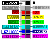
Color Codes
- The color numbers shown in these examples refer to the very large color palette in Windows. See below for an index to 16 main colors. You can also use the Widgets | Color Converter option to display the codes for any color you choose.

RockWare home page