The Borehole Manager Lithology table is used to enter observed lithologies. They can be typed in by hand, as described below, or imported from another source.
In Rockworks, "lithology" data represents your downhole rock or material types that aren't necessarily layered in a specific order. See Lithology versus Stratigraphy for more details about the difference between "lithology" and "stratigraphy".
The Lithology data table links to the Lithology Types Table where the lithologic materials are defined.
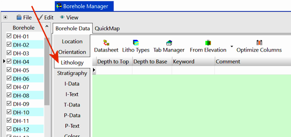
- Click on the Borehole Manager program tab.
- Create a new well if necessary, or click on the existing well to be edited.
- Click on the Lithology tab for the well.
These instructions are for hand-entering the data; please see the links at the end of this topic for other options.
- Depth to Top: Enter the measured depth to the top of the first lithologic interval for the well. ! The depth units must be the same as the Vertical units you defined for the project (and which are displayed on the Location table). For example, if the elevation and TD for the hole are shown there in feet, then the depth listings here must be in feet as well.
! The depth values must be positive.
- Depth to Base: Enter the measured depth to the base of the first lithologic interval for the well.
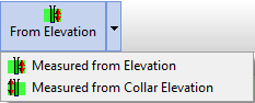
- From Elevation / From Collar Elevation: Use this button at the top of the table to define for this borehole which datum your depths were measured from. The designation will apply to the lithology data for all boreholes.
- Choose Measured from Elevation if the depths were measured from the ground elevation (entered as the "Z (Elevation)" field in the Collar Coordinates tab). This is the default setting.
- Choose Measured from Collar Elevation if the depths were measured from the collar elevation (entered as the "Collar Elevation" field in the Collar Coordinates tab).
-
- Keyword: Double-click in this cell and choose the material type from the Lithology Types Table. Or, you can single-click in this cell, click the small down arrow, and choose the material type from the drop-down list.
- If the material type is not listed, you'll need to add it to the current Lithology Types Table. See the Lithology Types Table topics for more information.
- Description: This optional field can be used for recording any additional notes about the interval. This is a "memo" field with unlimited content.
- This text can be plotted in 2D strip logs. Though the text will wrap in log columns, be warned that lengthy text may not display well in your logs.
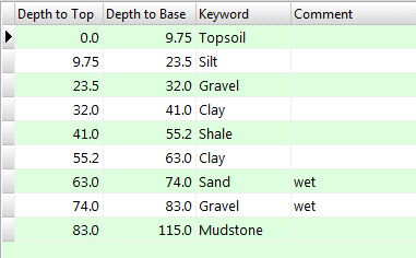
- Repeat this process for additional lithologic intervals. Remember that lithology intervals can repeat within a single borehole (sand, clay, sand, clay). Here's an example of how the lithology for one borehole might look:
 Back to Data Introduction

RockWare home page