RockWorks | ModOps | Grid | Fence | Single Grid
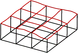
This program will plot a three-dimensional profile based on a single grid model, representing the intersection of the input surface and the fence panels. You may request regular fence panel spacing, in a variety of configurations, or you can draw your own panels. The profiles are plotted as three-dimensional tubes. These profile tubes can be combined with fence panels constructed elsewhere in the program.
Feature Level: RockWorks Basic and higher
Menu Options
Step-by-Step Summary
- Rules & Filters
Use the tabs at the top of the window to apply spatial filters, time/date filters, or stratigraphic rules to data being displayed in your logs. (More info)
- 3D Log Design
Click this tab at the top of the window to choose which data items are to be displayed in the logs, if activated via the Striplogs checkbox below, and in which order. This requires that you have data in the Borehole Manager database. See Using the 3D Log Designer and the Visible Item Summary.
- Fence Location
Click on this tab to draw, on a map display of your enabled boreholes, where the fence panels are to be placed. The most recent fence drawn for this project will be displayed (More info)
- Location Map
Insert a check in this tab, at the top of the window, to create, along with the fence diagram, a reference map that shows the fence panel locations.
Click on this tab to set up the map options. (More info)
-
- Grid Model
- Grid Model: Click to the right to browse for the name of the existing grid model (.RwGrd file) that is to be represented as a profile line in the fence panels. This grid model must already exist in your project folder. Some examples: If you have created a surface contour map of the borehole locations (Borehole Manager | Map | Borehole Locations) you could use that surface grid model as the source of the profile line in a lithology, stratigraphy, P-Data, I-Data, or other fence diagram. Or, if you have imported digital elevation data in the form of a grid model, you could use that as the source for the profile line.
- Profile:
- Color: Color to be used when plotting the 3D tubes that depict the surface profile.
- Radius: Radius (in percentage units) to be used when plotting profiles.
- Smoothing: If set to zero, the profile will have a "stair-step" appearance that is caused by the discrete nature of the grid model.
- Vertical Lines at Endpoints: If desired, vertical lines can be plotted along the edges of the fence panels. The elevation at the base of these lines is defined by the Base Elevation (see below).
- Color: Color to be used when plotting vertical edge lines.
- Radius: Radius (in percentage units) to be used when plotting vertical edge lines.
- Horizontal Line along Base: If desired, a horizontal line can be plotted along the base of each fence panel. The elevation for this line is defined by the Base Elevation (see below).
- Color: Color to be used when plotting horizontal base line.
- Radius: Radius (in percentage units) to be used when plotting horizontal base line.
- Manually Specify Base Elevation: Leave this box unchecked if the base elevation is to be defined by the minimum Z coordinate in the Project Dimensions menu.
You can check this box if you prefer to specify a different base elevation.
- Elevation: Elevation at which base line will be plotted.
-
- Other 3D Diagram Options: Use these checkboxes to append other layers to your 3D scene. (Summary)
- Striplogs: Append striplogs to your 3D scene. (More info)
- Draped Image: Include an image in this 3D scene, draped over an existing grid surface. (More info)
- Floating Image: Include an image in this 3D scene, floating at a specified elevation. (More info)
- Perimeter Cage Include a 3D reference cage around the diagram. (More info)
- Legends: Include one or more legends with the diagram.(More info)
- Infrastructure: Display buildings, pipes, or other infrastructure with your 3D scene. (More info)
- Faults: Include 3D fault panels with this scene. (More info)
- Other 3D Files: Include other, existing, RockPlot3D ".Rw3D" files in this scene. (More info)
- Output Options: Use these settings to define whether the output scene is to be saved (or displayed as "untitled"), how the file should be named, and whether it is to be displayed after it is created. It also offers export options. (More info)
This program requires that the grid model to be illustrated as a 3D profile (fence) already exists in the current project folder.
- Select the ModOps | Grid | Fence | Single Grid menu option.
- Enter the requested menu settings, described above.
- Be sure to click on the Fence Location tab to select the fence panel locations.
- Click the Continue button to proceed.
The program will look at the coordinates specified for the fence panels and determine the closest nodes along the slices in the input grid model. It will construct a vertical profile for each panel to illustrate the grid surface elevations, using the line style you selected. Additional diagram layers will be appended as requested. The completed diagram will be displayed in a RockPlot3D tab in the Options window.
- You can adjust any of the program settings via the Options tab to the left, and then click the Continue button again to regenerate the diagram.
- View / save / manipulate / print / export the image in the RockPlot3D window.
 Back to Grid Menu Summary

RockWare home page