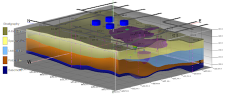
RockPlot3D is a 3-dimensional display program that is used by the Borehole Operations, ModOps, Utilities, and Graphics programs for display of 3D objects, such as stratigraphic and water level surfaces, solid models, strip logs, and other items such as bitmaps and storage tanks. These items can be displayed individually, or in combination as shown above.
RockPlot3D permits interactive movement of the display (rotate, zoom, pan) and easy viewing and hiding of image objects.
- Managing RockPlot3D Files (opening, saving, printing, etc.)
- Viewing RockPlot3D Scenes (rotating, vertical exaggeration, lighting, etc.)
- Manipulating RockPlot3D Scenes (turning items on/off, adjusting transparency, filtering models, etc.)
- RockPlot3D Reference Items (reference grids, axes, labels, etc.)
- RockPlot3D Data Items (logs, surfaces, solids, etc.)
- RockPlot3D Legends, Labels, and Logos (colors, stratigraphy, lithology; scene titles; company logos)
- RockPlot3D Tables (stratigraphy, lithology, well construction)
- Converting Coordinates (reprojecting the scene to another coordinate system)
- Print RockPlot3D Images
- Import Images into RockPlot3D
- Export RockPlot3D Scenes (raster, dxf, shapefiles, Google Earth. collada, Sketchfab)
- Create Animations of RockPlot3D Scenes
- Troubleshooting

RockWare home page