RockWorks | Utilities | Maps | Infrastructure
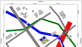
This program is used to read a list of entities such as buildings, roads, tanks, and walls and display them in a plan-view 2D map. The input for the 2D Infrastructure program consists of a text file that contains a series of objects and parameters.
Feature Level: RockWorks Basic and higher
- These infrastructure objects are also offered as a layer option in maps, 3D scenes, and cross sections elsewhere in RockWorks.
- They can also be displayed as a stand-alone 3D scene.
Menu Options
Step-by-Step Summary
- Spatial Filter: Insert a check in this box at the top of the program window to activate a data filter based on spatial coordinates. This only applies to the Borehole Locations overylay layer, if activated. Click this button to enter the filter settings. Click the Return to Previous Menu button when you are done entering the filter settings. (More info)
- Time Filter: Insert a check in this box at the top of the program window to filter the borehole Aquifer or T-Data based on date/time. This only applies to the Borehole Locations overylay layer, if activated. Click this button to enter the filter settings. Click the Return to Previous Menu button when you are done entering the filter settings. (More info)
- Infrastructure
- ASCII Input File: Click on this item to select the name of the user-created text file that contains the listing of infrastructure object and parameter commands.
- Entity Appearance: Choose Color-Filled for solid-filled objects, or Outline Only to display the object outlines with no fill.
- Plot Object Labels: Check this item to include object labels in the output map.
- 2D Map Layers
- Insert a check in any of the other map layers which are available to include them with your infrastructure map.
Click on the layer tab to establish the map settings. See 2D Map Layers for more information.
- Output Options: Use these settings to define whether the output graphic is to be saved (or displayed as "untitled"), how the file should be named, and whether it is to be displayed after it is created. It also offers export options. (More info)
- Create your external text file that contains the "Building", " Road", and other infrastructure commands, using Notepad or another program capable of saving documents as text-only. See Infrastructure Data Format for details. See the "Infrastructure_xx.txt" files in the RockWorks Data\Samples folder for examples of this type of file.
- Select the Utilities | Maps | Infrastructure menu option.
- Enter the requested menu settings, described above.
- Click the Continue button to continue.
RocWorks will read the commands within the text file and create a plan-view display of them, filled or hollow as requested. The completed map will be displayed in a RockPlot2D tab in the Options window, if requested.
- You can adjust any of the options along the left and click the Continue button to regenerate the infrastructure map.
- View / save / manipulate / print / export the image in the RockPlot2D window.
 Back to Map Menu Summary

RockWare home page