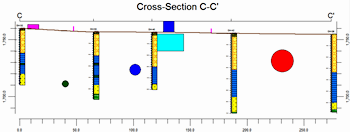

Use the Infrastructure checkbox, offered in all profile, section, and projected section menus, to read a user-specified Infrastructure File containing building, structure, tube, road, and wall locations; compute the intersections between these items and the vertical profile or section slices; and plot them within the diagrams.
V-Tanks, Buildings, and Sub-Buildings will be plotted accurately, meaning that their dimensions represent the distance between their walls as defined by the intersections of the vertical planes. Roads and tubes, however, will be plotted such that their symbol will be centered on the axis intersection with the vertical plane. The width of the roads will be set to whatever width was defined within the Infrastructure file. The radius of the tubes will be equal to the radius that was defined within the Infrastructure file. These caveats prevent extraneous road fragments and tube intersections plotted as ovals.