Borehole Operations Aquifers Menu - Summary
RockWorks | Borehole Operations | Aquifers Menu

The tools in the Aquifers menu are used to generate grid models for the upper and lower surface of a single aquifer or multiple aquifers recorded for a particular date or date range, as listed in the Water Levels table in the project database. The aquifer model can be displayed as a 3D diagram or sliced for display as a cross section, profile, fence diagram. 2D elevation or thickness contours and hydrograph diagrams are also available.


Model-Based Diagrams  -  Statistical Graphs

Model-Based Diagrams: Interpolate a surface models for downhole water level data, for display as:

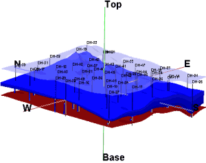
Grid-Based Model: A 3D display of the aquifer model (upper and lower surfaces + side panels). (More info)


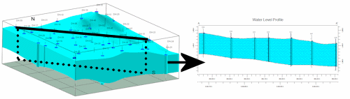
2D Profile: Create a profile diagram sliced between two points in the aquifer model, with projected striplogs, and color/pattern fills. (More info)


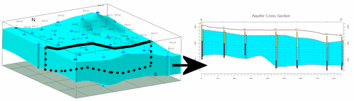
2D Multi-Panel Cross Section: Create a 2D multi-panel cross section, sliced between multiple points in the aquifer model, with vertical striplogs at panel edges, and color/pattern fills. (More info)


2D Multi-Panel Cross Section with Projected Logs: Create a 2D multi-panel cross section, sliced between multiple points in the aquifer model, with striplogs projected onto panels, and color/pattern fills. (More info)


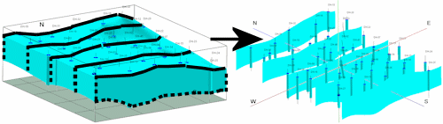
Fence: Create a 3D multi-panel fence diagram, sliced between multiple points in the aquifer model, with 3D logs and and other layer options. (More info)


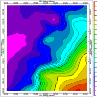
Plan Map: Create a 2-dimensional (flat) contour map of the aquifer surface, base, or thickness. (More info)


Statistical Graphs

Hydrograph: Display water levels and precipitation over time for a single borehole. (More info)


Hydrograph Map: Display water levels and precipitation over time for all enabled boreholes as mini-hydrograph diagrams at each borehole location. (More info)


Google Earth Billboards: Display water levels and precipitation over time for all enabled boreholes as mini-hydrograph diagrams in vertical "billboards" in Google Earth. (More info)


Back to Borehole Manager Summary

RockWare home page