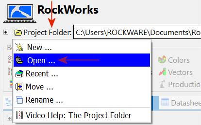
! You need to select the name of the FOLDER; the program is not asking you to select the name of any particular file.
! Don't select the "System" folder inside your project folder.
=====================================================
This project appears to be a RockWorks15 project.
"full project path"To upgrade a RockWorks15 project to a RockWorks20x project, a new project folder
and database will be created and your RockWorks15 project data copied into it.=====================================================
Do you wish to proceed?
=====================================================
( * If you see an error when opening the RockWorks15 project folder, please refer to the Troubleshooting help topic.)
Click Yes to continue with the process of opening a RockWorks15 project folder.
If you select Yes, you'll be presented with a series of screens where you will define the location of the new project folder, the coordinate system and units for the existing project, and the output coordinates for the new project.
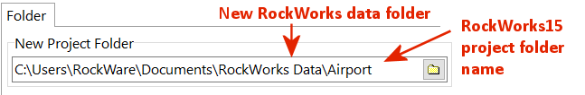
- New Project Folder: The default name that will be displayed here is the name of your RockWorks15 project (such as "Airport"), now in the RockWorks Data folder.
If this is not acceptable, you can use the
button to browse for a different location for this new project folder.
! Do not save the RockWorks20 project in the RockWorks15 project folder.
- Database Engine:
- Use Default Database Engine: Choose this option to use the default database engine (SQLite).
- Customize the Database Engine (Advanced): Select this option to display advanced settings that allow you to customize the database to be used. (More info...)
- New Project Settings:
- Base the New Project on an Existing Project: This should be the default setting. This will enable RockWorks to bring in data from the existing project.
- Click the Next button, at the bottom of the window, to proceed to the next tab.
- Base the New Project on the Following Project: The default displayed here will be the name of the RockWorks15 project you're opening. This should remain selected.
- Use the database structure, types tables and borehole data: This should be the default selection, so that all data from the RockWorks15 project will be brought into the new RockWorks20 project. This option should remain selected.
- Copy Project Menu Settings: This should be checked by default so that the menu settings (such as gridding methods, contour line styles, etc.) will be brought into the new project. Leave this checked.
- Copy Project Support Tables: This should be checked by default so that the "Misc Support Tables" will be brought into the new project. Leave this checked.
- Copy Other Files: Click this button to select any of the following files from your RockWorks15 project to be converted (when applicable) and copied to the new project folder:
- Utilities Datasheets: Check this box to have all of the .ATD datasheet files in the RW15 project converted to the new .RwDat file format and copied to the new RockWorks project folder. (The original files will remain intact.)
- Grid Models: Check this box to have all of the RW15 grid models (.GRD files) converted to the new .RwGrd file format and copied to the new RockWorks project folder. (The original files will remain intact.)
- Solid Models: Check this box to have all of the RW15 solid models (.MOD files) converted to the new .RwMod file format and copied to the new RockWorks project folder. (The original files will remain intact.)
- RockPlot2D Diagrams: Check this box to have all of the RockPlot2D diagrams (.RK6 files) in the RW15 project converted to the new .Rw2D file format and copied to the new RockWorks project folder. (The original files will remain intact.)
- RockPlot3D Scenes: Check this box to have all of the RockPlot3D diagrams (.R3DXML files) in the RW15 project converted to the new .Rw3D file format and copied to the new RockWorks project folder. (The original files will remain intact.)
- ReportWorks Diagrams: Check this box to have all of the ReportWorks diagrams copied to the new folder. Note that no conversion occurs.
Note that these conversions are the same as those offered in the stand-alone program "ConversionTool.exe" which is installed with RockWorks20.
- Click the Next button at the bottom of the window to proceed to the next tab.
- Horizontal Coordinates and Units: These settings are used to establish the coordinate system (e.g. projection) and units (feet or meters) in which your boreholes are defined.
Don't know your coordinate projection? No problem. You can just define a generic system (choose "Local (Custom)"). If you ever want to assign a projection or re-project the coordinates, there are tools for that, as well.
- Local (Custom): Choose a Local Coordinate System if:
(a) you don't know or care what coordinate system your data represent,
(b) your coordinates are based on a local (not-global) grid system,
(c) your projection is not listed here.- Local Coordinate System Origin: Use these prompts to enter a known longitude (X) and latitude (Y) coordinate for the 0,0 location for your local coordinate system. This offers a means of geo-referencing your local coordinates.
! Since RockWorks15 coordinates were basically "unitless", if you're opening a RockWorks15 project and don't know what projection to use, select Local coordinates with 0,0 origin. - Units: Choose Feet or Meters for the units in which these local coordinates are defined.
- Local Coordinate System Origin: Use these prompts to enter a known longitude (X) and latitude (Y) coordinate for the 0,0 location for your local coordinate system. This offers a means of geo-referencing your local coordinates.
- State Plane: Choose this option if your XY coordinates are referenced to a State Plane projection system.
- State Plane Coordinate Zone: Click on this button to select the Zone for the coordinates.
- Units: Choose Feet or Meters for the units in which these State Plane coordinates are defined.
- UTM: Choose this option if your XY coordinates are referenced to a UTM projection system.
- Datum: Click on this button to select the Datum for the UTM coordinates.
- Zone: Click on this button to select the UTM Zone.
- Units: Choose Feet or Meters for the units in which these UTM coordinates are defined.
- Other: Choose this option if your XY coordinates are referenced to another projection system not listed here. (More info)
- Local (Custom): Choose a Local Coordinate System if:
! For RockWorks15 projects, it is assumed that the horizontal and vertical units were the same, so this should match the units you defined above.
Choose either Feet or Meters.
==============================================
Please confirm your choice of Units:
==============================================
The horizontal units: units (coordinate system).
- other coordinate settings
The vertical units: units.The Output Units (horizontal and vertical): units.
==============================================
Do you wish to use these settings?
==============================================
If you need to adjust any settings, click No, and you'll be returned to the previous window.