RockWorks | ModOps | Grid | Statistics | Scattergram
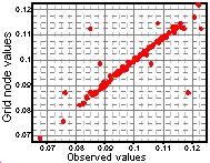
Use this program to create an XY plot or scattergram of observed Z values versus computed node Z values for corresponding locations in an existing grid model (".RwGrd" file).
! This program requires that the source data, from which the grid model was computed, be displayed in the RockWorks Datasheet so that source data can be compared to the gridded data.
See the Grid Residuals program if you want a listing of the actual values which represent the difference between the original data and the model.
Menu Options
Step-by-Step Summary
- Data Columns:
- X (Easting), Y (Northing): Select the columns in the main data sheet that contain the X and Y location coordinates for the source data, from which the grid model being analyzed was generated. The observed data is required to generate this diagram.
- Z (Elevation): Select the data sheet column that contains the original Z values that are modeled in the grid model. These source Z values will be plotted along the X axis, against the computed node values.
- Grid File: Click on this item to select the name of the existing grid file, created from the data in the main data sheet, whose node values are to be displayed against the source Z values in the scatter plot.
- Titles
- Primary: Type in the text, if any, for the main diagram title. Click the buttons to the right to choose a font style, size, and color.
- Secondary: Type in any text to plot for a secondary title below the primary title text. Click the buttons to the right to select a font style, size, and color.
- Symbols: Check this item to include symbols on the diagram. Click on this tab to select the desired symbol style and color for the scattergram points. (More info)
- Labels: Check this item to include labels with the points. Click this tab to define the data columns for the labels. Plotting labels is generally not advised because of the large number of control points. (More info)
- Curve Fitting
- Connect Points: Check this this box to activate the plotting of a line between scattergram points. This is typically used with data plotted in a sequential fashion over time along the X axis. Click the box to select line style and color.
- Smooth Curve Fit: Check this item to activate the plotting of a smoothed line between data points. This is a point-to-point line, not a polynomial curve fit to the data points.
- Style/Color: Click to the right to choose the line style, color, and thickness for the curve
- Smoothing Factor: The program can smooth the curves in one or more passes resulting in more pleasant-looking lines. However, smoothed lines may not always honor the original points. Click on this item to enter the number of times the lines should be run through the "smoother".
- Linear Regression: Insert a check here to illustrate the linear "relatedness" of the X and Y variables by plotting the best-fit line among the data points and by reporting relatedness in terms of the correlation coefficient.
- Style/Color: Click to the right to choose the line style, color, and thickness for the regression line.
- Show Correlation Coefficient: Insert a check here for the program to display a small window prior to plotting the scattergram that lists the computed correlation coefficient for the selected columns.
The correlation coefficient ranges from -1 to + 1. A value of 1.0 indicates a perfect direct relationship between the variables. A correlation coefficient of 0.5 indicates that there is some relationship, and a correlation of 0 indicates no relationship at all between the two variables.
Negative correlation coefficient values indicate one variable is increasing while the other decreases. Like the positive values, a correlation of -1 indicates a perfect, though inverse, relationship, and a correlation of -0.5 reflects a less than perfect inverse relationship.
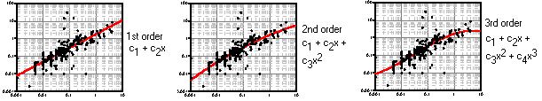
- Polynomial Fit: Check this box if you want the program to fit a polynomial equation to the data points and to offer a statistical display.
- Style/Color: Click to the right to choose the line style, color, and thickness for the regression line.
- Order: Click on this item to select the order of the polynomial to be fit to the data. See the diagrams below for examples of first through third order polynomials. You may select a fourth or fifth order polynomial (with 3 or 4 bends, respectively), but you probably won't want to go higher than that since few natural phenomena are truly higher order occurrences. RockWorks will, however, permit up to 10 orders.
-
- Show Equation & Std Dev.: Check this box to display the computed standard deviation and polynomial equation prior to creating the diagram.
- Border: Check this item to activate the plotting of titles, ticks, and labels along the horizontal and vertical axes. Click on this tab to access the settings.
- Left/West Axis, Right/East Axis, Basal/South, Top/North Axis: Insert a check in any of these check-boxes to activate their plotting.
- Plot Ticks: To turn tick marks on for any activated axis, insert a check in the appropriate check-box. Set the size (as a percent of the diagram width) and color.
- Plot Labels: To turn labeling on for any activated axis, place a check in the appropriate check-box. Set label angle, size (as a percent of the diagram width), color, and font type.
- Plot Title: To turn title on for any activated axis, place a check in the appropriate check-box. Enter the text to be plotted for the title, and set label angle, size (as a percent of the diagram width), color, and font type.
- Subdividers: Use these settings to turn on/off the plotting of a horizontal and/or vertical grid of lines, at major and minor intervals. Once activated, choose the colors and line styles for the selected grids.
- Manual Ranges: Check this box if you want to establish a range of data for the diagram that is either less than the actual data values (to filter the data), or greater than the actual data values (to extend the axes for comparing different data sets). If the Manual Ranges check-box is left blank, the program will use all scanned data and dimension the X and Y axes to accommodate those data.
- X Minimum, X Maximum: Click on these items to type in the minimum and maximum data values to be represented for the X axis (observed values).
- Y Minimum, Y Maximum: Click on these items to type in the minimum and maximum data values to be represented for the Y axis (solid model node values).
- Manual Subdivision: Insert a check here to override the program-computed axis labeling intervals.
- X Minor: Type in the interval for the X axis at which small tick marks are to be plotted.
- X Major: Enter the X axis interval at which major tick marks and labels are to be plotted. This must be an even multiple of the X Minor setting.
- Y Minor: Type in the interval for the Y axis at which small tick marks are to be plotted.
- Y Major: Enter the Y axis interval at which major tick marks and labels are to be plotted. This must be an even multiple of the Y Minor setting.
- Diagram Size: Enter the height and width of the diagram. These values would typically represent inches, however note that you can scale the diagram both larger and smaller for both screen display and printer output in the RockPlot2D plotting window.
- Scaling: Choose between Linear and Logarithmic scaling for both the horizontal (observed points) and vertical (model values) axes.
- Other 2D Files
Check this option to include existing RockWorks diagrams as layers with the current diagram.
Click on this tab to select the existing diagrams (.Rw2D files) to be included. (More info)
- Peripherals
Check this option to include various peripheral annotations with your diagram. Options include titles, scalebars, and more.
Click on this tab to activate the items and establish their settings. (More info)
- Border
Check this option to include a solid line border around the entire diagram.
Click on this tab to specify the line style, thickness, and color.
- Output Options
- Save Output File: Check this to assign a name for the diagram in advance, rather than displaying it as Untitled.
- Automatic: Choose this option to have RockWorks assign the name automatically. It will use the name of the current program plus a numeric suffix, plus the ".Rw2D" file name extension.
- Manual: Choose this option to type in a name of your own for this file.
- Display Output: Check this option to have the resulting diagram displayed in RockPlot2D once it is created.
- Access the RockWorks Datasheet program tab.
- Open the XYZ data from which the grid model was created. This is necessary because the program needs to know the original observed values against which the grid model values will be compared.
- If the model was originally created in the ModOps menu from XYZG data in the datasheet, use File | Open or the Project Manager to open this RwDat file.
- If the grid model was created in the Borehole Manager, you can transfer the original data to the Datasheet for use with this program, using several methods:
- For elevations at the top of the well, use the Borehole Manager's File | Transfer | Locations -> Datasheet option to transfer Location tab data.
- For stratigraphic elevations, use the Borehole Manager's File | Export | Stratigraphy Data -> Utilities Datasheet option to transfer stratigraphic data to the Utilities datasheet.
- For water level data, use the Borehole Manager's File | Export | Aquifer Data -> Utilities Datasheet tool to transfer water level data to the Utilities datasheet.
- Select the ModOps | Grid | Statistics | Scattergram menu option.
- Enter the requested menu settings, described above.
- Click on the Process button to create the scattergram.
The program will read the original data values from the Datasheet. It will determine the calculated grid model Z-values for each control point location and create an X,Y scattergram of observed versus calculated Z-values. It will include a best-fit line through the points, and post the correlation coefficient. This number ranges between zero (no correlation) to 1.0 (perfect correlation). Note: The correlation coefficient provides a quantitative comparison between the observed data and the predicted model. It does not reflect how reasonable the model is. The diagram will be displayed in a RockPlot2D tab in the Options window.
- You can adjust any of the settings in the Options window and then click the Process button again to regenerate the diagram.
- View / save / manipulate / export / print the diagram in the RockPlot2D window.
 Back to Grid Menu Summary

RockWare home page