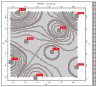
The Symbol Labels layer is available for 2-dimensional maps and diagrams. It is used to create a map layer that accompanies symbols with a variety of text labels..
! Note that this program reads the label text from the current Datasheet file.
- Content
- Plot Label: Northeast, East, Southeast, etc: Insert a check in the boxes for the labels to be plotted. For example if you want a single label plotted to the northeast of the symbol, you would check the Northeast box. Then, for each activated label, you can define the following:
- Data Column: Click the down-arrow to select the name of the column in the data sheet that contains the information to be plotted as labels. If you wanted the sample ID to be plotted, for example, you would choose the column that lists the sample IDs.; You can select a different column for each activated label.
- Text: Click on the color box to choose a color for the label text.
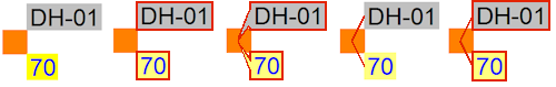
- Fill Bkgnd.: Insert a check here if you want the label to be plotted on an opaque rectangle, and (if so) choose the background color for the label. See also the Perimeter settings, which can include a frame outline, leader line, or pointer from the label to the map symbol.
- Prefix, Suffix: In these prompts, you may type in any alphabetic or numeric characters to be plotted before (prefix) or after (suffix) the label text specified in the selected data column. For example, if the sample ID is entered as "123" and the Prefix is entered as "BH", then the label will print as "BH123"
- Leader Lines: Select label outline options, which will apply to all active labels. You can include a pointer, frame, and/or leader line, and select their color and line styles. These examples illustrate the perimeter options with Northeast and Southeast labels (horizontal orientation).
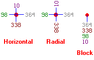
- Orientation: Here you can select the angle of the label text: horizontal (the labels read left to right), radial (angled like a spoke), or block (stacked).
- Dimensions:
- Initial Offset: Click to enter the distance from the map symbol the label should be placed. The offset is declared as a percent of map width, just like the label dimensions. At "0" the label will be placed right next to the symbol.
- Font Size: Choose font size, as a percent of the dimensions of the project area.
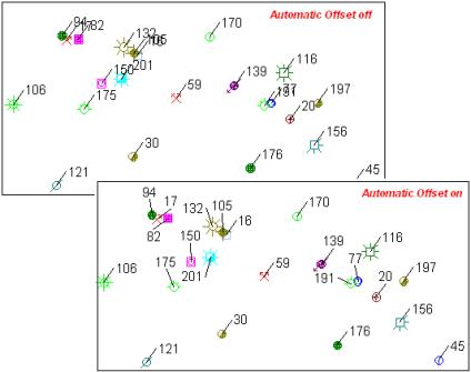
- Automatic Offset: Check this to activate automatic label positioning. This positions the point labels so that they do not overplot adjacent symbols or other labels. This method uses a spiraling algorithm whereby labels positions are rotated around the control point until an open "spot" is found. If an open location is not found, the search radius is increased and the entire process is repeated. For best results, use the Horizontal labeling orientation, establish the smallest possible label size (Dimensions) and then activate the automatic positioning. Automatic offset can significantly increase map processing time.
-

RockWare home page