The Dimensions tab in the RockWorks Project Settings is used to establish the coordinate extents of your project area, from west-to-east along the X axis, from south to north along the Y axis, and from lowest to highest elevations along the Z axis. The Project Dimensions are used to dimension grid models and solid models you create and to scale all of your map and diagram components - text, log widths, etc.
The coordinates can be typed in by hand, scanned from your data, and imported from file. You can view statistics, preview the extents, show them in Google Earth, and identify model cells which are overpopulated.
If the Dimensions tab is not visible, click the small button to the left of the project folder name. This toggles between "+" (expanding) and "-" (hiding) the Project Settings tabs.
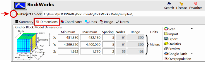
- Grid & Block Model Dimensions: This section of the Dimensions pane defines the coordinate extents of the project area - the minimum and maximum coordinates along the X, Y, and Z axes. (More info)
You can type the coordinates in manually, or (easier) use one of the following options to establish them.
- Scan Boreholes: Use this button to scan the data in the borehole database to establish the coordinate extents. (More info)
- Scan Datasheet: Use this button to scan the data in the RockWorks datasheet to establish the coordinate extents. (More info)
- Import: Use this button to import the coordinates from a previously-saved file.
- Export: Exports the current dimensions settings to a file.
- Statistics: Click this button to view a text summary of the project dimensions: units, midpoint, distances, grid model properties, and solid model properties.
- Preview: Click this button to see a cartoon of the overall shape of the project and the density of the model nodes.
- Show in Google Earth: Use these options to view the project area in Google Earth. These options require that you have Google Earth installed separately on your computer. It is not included with the RockWorks installation.
- Simple: The dimensions grid will be shown in Google Earth, no settings to establish.
- Drape (Advanced): Drape the project dimensions grid over the ground surface in Google Earth. (More info)
- Float (Advanced): Float the project dimensions grid at a defined elevation in Google Earth. (More info)
- Identify Overpopulated Cells: Use this to create a quick report of any cells that contain more than one borehole, to identify clustered holes or too-coarse node spacing. (More info)
- Global settings for information about settings which apply to all projects in RockWorks.
- Project Subsites for information about working with smaller areas / groupings of boreholes within a project.
 Back to Project Settings

RockWare home page