RockWorks | ModOps | Grid | Math | Grid & Grid
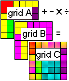
This program performs arithmetical operations with the grid node Z-values in two existing grid files.
Examples: Add together thickness values in two isopach grid files to determine total thickness of adjacent beds. Subtract the formation top elevations in one grid file from those of the next formation up to generate an isopach model of that formation. Multiply a coal thickness grid file by a Boolean grid file representing favorable coal BTU values to generate a thickness model of favorable areas only. Divide a grid model representing overburden values by a grid representing a clay seam’s thickness to determine stripping ratio.
! In order for the program to match up corresponding nodes in the two input grid files, they must have the same dimensions (X and Y coordinates and range) and numbers of nodes. If you aren’t sure of the "size" of any grid file, use the Grid | Statistics | Report option to obtain a summary. During gridding, you can manually establish the grid dimensions and node spacing by activating the Confirm Model Dimensions check-box in the Model Dimensions window. See Resampling Grid Models if you need to re-dimension an .RwGrd file.
Menu Options
Step-by-Step Summary
- Math Options
- Grid A (Input): Click here to browse for the name of the first existing grid file (.RwGrd file) that the program is to read and manipulate.
- Grid B (Input): Click here to browse for the name of the existing grid file containing the node values to be added to, subtracted from, multiplied to, or divided into each node in the input grid file "A".
- Grid C (Output): Click to the right to type in the name to assign to the new grid file (.RwGrd) that the program will create, which results from the selected operation.
- Type of Operation
- Add: C = A+B: Choose this option to add corresponding node values in Model A and Model B, storing the sum for each node in the output model.
Example: Add two adjacent thickness grid models to output total thickness values.
- Subtract: C = A-B: Choose this option to subtract node values in Model B from the corresponding nodes in Model A, storing the difference for each node in the output model.
Example: Subtract a lower surface grid from an upper one to output thickness values.
- Multiply: C = A*B: Choose this option to multiply the corresponding node values in Models A and B, storing the resulting product for each node in the output model.
Example: Multiple a grid with a Boolean grid (containing 0's and 1's) to zero out areas where defined criteria are not met.
- Divide: C = A/B: Choose this option to divide node values in Model A by corresponding node values in Model B, saving the results for each node in the output model.
Example: Divide an ore thickness grid by an overburden thickness grid to determine stripping ratios.
- Average: C = (A+B)/2: Choose this option to determine the average for each node in Models A and B, storing the results for each node in the output grid.
Example: Compute average hydrothermal temperatures between two different dates.
- Difference: C = abs(A-B): Choose this option to determine the absolute value of the difference between node values in Models A minus B.
Example: Isolate areas where water levels have changed (up or down) between two different dates.
- Highest-Value: If A > B then C = A, else C = B: Choose this option if the nodes in the output model are to be assigned the highest value for the corresponding node in the input models.
Example: Find multi-variate anomalies based on surface geochemistry (assuming that the models have been standardized).
- Lowest-Value: If A < B then C = A, else C = B: Choose this option if the nodes in the output model are to be assigned the lowest value for the correponding node in the input models.
Example: Isolate optimal water well sites based on groundwater contamination models (assuming that the models have been normalized).
- AND: if A=1 AND A=B then C=1, else C=0: Choose this if you are inputting Boolean models containing values of 1 (for "true") and 0 (for "false") and you want "true" values saved to the output file where corresponding nodes in the input files are both set to "1".
Example: Isolate coal seams where both the BTU and sulfur levels are acceptable (the input grids represent Boolean models).
- OR: if A=1 OR B=1 then C=1, else C=0: Choose this if you are inputting Boolean models containing values of 1 (for "true") and 0 (for "false") and you want "true" values saved to the output file where corresponding nodes in either of the input files are set to "1".
Example: Identify areas within a contaminated groundwater in which either Contaminant "A" or Contaminant "B" exceed acceptable levels (assuming that the input grids represent boolean models).
- XOR: if A< > B then C=1, else C=0: Choose this if the nodes in the output model are to be assigned "1" when corresponding nodes in the input files (Boolean or real number) are not equal, and the output nodes are to be "0" where the input nodes are equal.
Example: Isolate areas where electromagnetics differ from magnetics (assuming that the input grids have been normalized).
- Null Processing: Use these settings to determine how null values in the grid model are to be handled in the mathematical operations.
- Result Always Null: Choose this option if a null value in either input grid should force the output of a null value for the corresponding node in the output file. This was the default method for RockWorks until the following new options were added.
Example: You are adding grids that represent reserves of different coal grades; areas in one model that are below economic cutoff and set to null will force the output grid to also be null in those areas.
- Result Always: Choose this option if a null value in either input grid should force the output of a specific value for the corresponding node in the output file. Click in the prompt to type in the Null Result.
- Treat Nulls as "0" Value: Choose this option if null values are to be treated as if they were values of "0" for the purposes of the selected mathematical operation. (Handy for addition and subtraction operations.)
Example: You are adding grids that represent reserves of different coal grades, and you want cumulative totals. By treating nulls as "0", null areas in one grid won't null out the totals.
- Treat Nulls as "1" Value: Choose this option if null values are to be treated as if they were values of "1" for the mathematical operation. (Handy for multiplication and division operations.)
- Treat Nulls as...: Choose this option if null values are to be treated as if they are a user-defined value for the mathematical operation. Type the value into the prompt.
- 2D Grid Map
Check this box to display the output grid as a 2D map at this time.
Click this tab to set up the 2D map layers (bitmap, symbols, labels, line contours, color-filled contours, labeled cells, map border, etc.).
- 3D Grid Diagram
Check this box to display the output grid as a 3D surface at this time.
Click this tab to set up the 3D map layers (surface colors, images, reference cage, etc.).
! You can request both a 2D and 3D representation of the grid model.
- Select the ModOps | Grid | Math | Grid & Grid menu option.
- Enter the requested menu settings, described above.
- Click the Process button to continue.
The program will load the input grid model (Model "A"), perform the requested operation on each of the grid node Z-values using the corresponding node values in the specified Model "B" grid file, and store the resulting grid file on disk under the output file name you selected for Model "C".
The requested diagram(s) will be displayed in a RockPlot2D tab and/or RockPlot3D tab in the Options window.
- You can adjust any of the settings in the Options window and then click the Process button again to regenerate the diagram(s).
- View / save / manipulate / export / print the diagram in the RockPlot2D or RockPlot3D window.
 Back to Grid Menu Summary

RockWare home page