RockWorks | Utilities | Coords | Public Land Survey -> XY
This program is used to generate X,Y coordinates for each corner of leases that are listed with Range, Township, Section descriptions (quarter/quarter or lots).
! In order to perform this type of polygon "spotting," you must have downloaded the RockWare "Landbase" collection of Public Land Survey (PLS) Township and Range data for most of the United States (from the US Bureau of Land Management Land Survey Information System and other sources). See the Landbase Overview for a discussion of this information and for coverage maps and tables.
Menu Options
Step-by-Step Summary
- Input: Select the names of the columns in the datasheet where the source data resides. Note that the Range, Township, and Section numbers must be listed in separate columns. (See the data link below for details.)
- Meridian: Select the name of the datasheet column that contains the Principal Meridian in which the Township is located. This is required in the event that a project spans more than one Meridian.
- Range: Select the name of the column in the datasheet that contain the Range numbers. These must be entered with the Range number followed by the letter "E" or "e" or "W" or "w", with no spaces separating the number and letter. The number must precede the letter.
- Township: Select the name of the column in the datasheet that contain the Township numbers. These must be entered with the Township number followed by the letter "N" or "n" or "S" or "s", with no spaces separating the number and letter. The number must precede the letter.
- Section: Select the name of the column in the datasheet that contain the section numbers. These must be entered with the Section number (1 - 36) in which the well is located.
- Location: Select the name of the column in the datasheet that contain the location descriptions. The well locations can be listed in either quarter/quarter format or in footage listings.
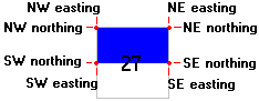
- Output: For these prompts, select the names of the columns in the current datasheet into which the program is to record the computed X and Y coordinates for each corner of each lease block. (8 columns total.) These should be blank columns, as the computed coordinates will replace any current data listed in the columns.The coordinates will be output in your project coordinate system and units.
The example below shows how the listed lease, the north half ("N2") of Section 27, would have 8 total coordinates spotted for its corners.
- Access the RockWorks Datasheet program tab.
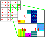
- Create a new datasheet and enter or import the lease location descriptions. This file must list the Range, Township, and Section of the leases to be spotted, and a location description such as "W2" or "NE/NW" or "L4".
Or, open one of the sample files and replace that data with your own. See Data Layout for datasheet examples.
! Click the Example button at the top of the window to load a sample file that is installed with the program.
- Download the RockWare Landbase for a library of reference coordinates for the translation.
- Select the Utilities | Coords | Public Land Survey -> XY menu option.
- Enter the requested program settings, described above.
- Click the Continue button to proceed.
The program will read the lease location descriptions, in quarter/quarter or lot format, and determine the X and Y coordinates of their corner points using the reference Land Grid Table. The coordinates will be recorded in the your output units in the requested datasheet columns.
- If no coordinates are recorded by the program, check that the Range(s) and Township(s) listed in the data (.RwDat) file are also referenced in the RockWare Landbase.
- If you wish to create a map of these lease polygons, use the Map | Oil Leases program. This map can be combined with a section boundary map of the reference land grid.
 Back to Coords Menu Summary

RockWare home page