 HydroStratigraphy Types Table
The Borehole Manager database uses HydroStratigraphy data tables for entry of depth intervals and hydrostratigraphic unit names for each borehole. These hydrostratigraphic intervals can be illustrated in strip logs, as surface maps, fence diagrams, and more using the program's tools.
The HydroStratigraphy Types Table defines for the program the names of the hydrostratigraphic units for the current project, the graphic pattern / color to use for each unit in logs and other diagrams, the order of the units (upper to lower), and other items. It serves as the reference library for the downhole aquifer and hydrostratigraphic data. This table is stored in the project database and links to your borehole data.
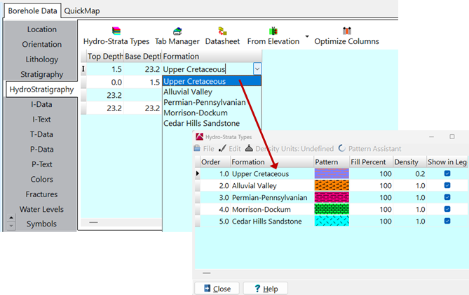
The HydroStratigraphy Types Table lists for each unit:
- The hydrostratigraphic units order, from the ground downward. (This "G" value will also be assigned for that layer in hydrostratigraphic solid models, should you decide to save them.)
! If possible, each unit should have a unique number, and these should increase for each deeper hydrostratigraphic unit. However, if your hydrostratigraphic sequence is poorly defined (as in some imported datasets), then you can use the HydroStratigraphy Rules to compensate for this.
- The hydrostratigraphic units name. This field will link to the HydroStratigraphy data table.
- The pattern and colors to be used to represent the hydrostratigraphic unit in diagrams. Double-click on the pattern cell to choose the pattern design, foreground color, and background color.
! Don't use white for all of the pattern backgrounds because the different hydrostratigraphic units won't show up in 3D models and 3D logs, which use only the background colors.
- The percent fill for the pattern, which determines how much of the striplog column width the pattern will fill. This is used for striplogs only.
- The hydrostratigraphic units density, which is used only for volume/mass computations.
- Whether the hydrostratigraphic unit is to be displayed in any diagram legends and in the pop-up list linked to the hydrostrata data tables. This setting can also be used to define whether the unit is to be included in hydrostratigraphy models and diagrams.
 Back to Tables summary

RockWare home page