RockWorks | Utilities | Survey | XYZ
This program is used to convert survey data (in a bearing, inclination, distance format) to XYZ coordinates.
Feature Level: RockWorks Basic and higher
Menu Options
Step-by-Step Summary
- Data Columns
- Control Points: The first five input prompts establish the columns in the datasheet in which you have listed control point information. For each prompt, select the name of the column in the input survey data file in which the requested information is listed.
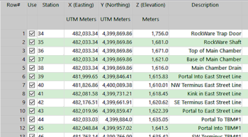
- Station #: The station number.
- Station Description: The description for this station.
- Station X: The station's X-coordinate or Easting.
These can be Eastings in meters or feet, decimal longitudes, etc. See Defining your Datasheet Coordinates for more information.
- Station Y: The station's Y-coordinate or Northing.
- Station Z: The station's elevation.
Be sure you have defined the units for this column. See Column Setup for more information.
- Survey Data: These prompts establish the columns which list the survey data which reference the known and the computed stations. Be sure the units for the distance and height (feet or meters) are defined. They can represent different units.
- "From" Station: The station number FROM which the survey measurement was taken.
- "To" Station: The station number TO which the survey measurement was taken.
- Bearing: The compass bearings from the "from" station to the "to" station.
- Inclination: Inclination from the "from" station to the "to" station. See the format definition below.
As above, be sure you have defined the units for this and the following linear measurement columns. See Column Setup for more information.
- Distance: Distance from the "from" station to the "to" station.
- Instrument Height: Height of measurement instrument. If this is not known, the values in this column can be set to zero.
- Target Height: Height of measurement target. If this is not known, the values in this column can be set to zero.
- Directionality: Choose how the directional data are recorded in the datasheet.
- Declination
- Magnetic Declination Correction: Enter any declinaton correction as described in the program dialog.
- Inclination: Select the format of the inclination measurements you have entered. Choose from:
- Up = 90 Degrees, Horizontal = 0 Degrees, Down = -90 Degrees
- Up = 0 Degrees, Horizontal = 90 Degrees, Down = 180 Degrees
- Output Options
Click this tab to define the output format(s) for the report. (More info)
- RwDat (RockWorks): Click in this button if you want the report generated in a RockWorks datasheet (.RwDat) format.
- CSV (Excel): Click in this button if you want the report generated in a CSV file format for use in Excel.
- TXT (Notepad): Click in this button if you want the report generated in a text (.txt) format.
- RTF (Word): Click in this button if you want the report generated in an RTF file format for use in Word.
- Access the RockWorks Datasheet program tab.
- Create a new datasheet and enter or import your survey data.
Or, open one of the sample files and replace that data with your own. See Data Layout for datasheet examples.
! Click the Example button at the top of the window to load a sample file that is installed with the program.
- Select the Utilities | Survey | XYZ menu option.
- Enter the requested menu settings, described above.
- Click the Continue button to proceed.
The program will compute the XYZ coordinates from the source survey information and list them in the requested ouput format(s).
 Back to Survey Menu Summary

RockWare home page