Changing Column Titles, Styles, and Units
RockWorks | Datasheet | Columns | Column Properties
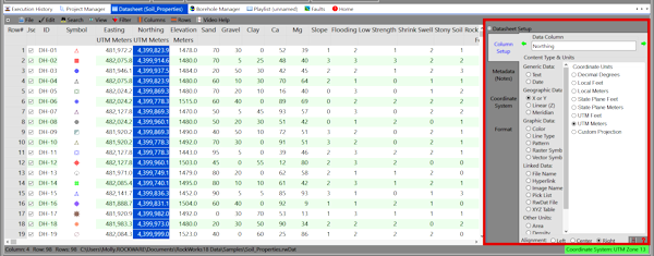
Use this Datasheet menu option to change the text displayed in the column headings, to change the units for any spatial data, and to change the style in which data are displayed in the columns. The datasheet allows graphic symbols, lines, colors, and patterns to be displayed in columns, as well as basic alphanumeric text. You can also set up cells to link to other files. The column characteristics are accessed in the Datasheet Setup pane on the right side of the wndow. The column characteristics are stored in a header block in the rwDAT file.
- Title: This field in the Settings window lists the name of the current column. It is the title which is displayed in the heading cells at the top of the datasheet.
- Content Type and Units: This section is where you establish what kind of information is stored in the column.
- Access the RockWorks Datasheet program tab.
- Open the datasheet to be manipulated.
- Locate the Datasheet Setup pane along the right side of the datasheet. (If this is not visible, select the Datasheet | View | Column Properties command, or right-click in the column heading area - the gray part - and select the Column Properties option.)
- Use the Previous or Next arrow buttons to advance/backtrack to the column you wish to modify.
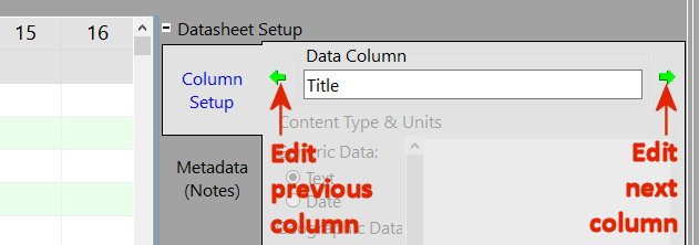
- To change the column's Title, click in the Title cell and edit/replace the existing text. We recommend that you limit the column names to 20 characters, including spaces.
- To change the column Type, click in the appropriate radio button. If requested, you'll also need to specify the Units.
- Generic Data
- Text columns display their contents as textual characters, both alphabetic and numeric. (More info)
- Date columns contain dates. (More info)
- Geographic/Spatial Data columns contain coordinate information.
- X or Y Coordinate columns contain map location coordinates. You must define the coordinate type and units that the X or Y coordinates represent. (More info)
- Linear (Z) Dimension columns contain elevation (Z), distance or other linear data measurements. You must define the units these values represent. (More info)
- Meridian columns contain meridian numbers for public land survey (PLSS) data. (More info)
- Pick List columns retrieve preconfigured lists of items to choose from in a quick-select window (rock types, etc.). (More info)
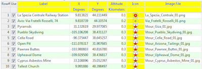
- Graphic Data columns display graphic items.
- Color columns display blocks of color. (More info)
- Line Type columns display graphic lines in a user-selected color. (More info)
- Pattern columns display graphic patterns. (More info)
- Raster Symbol columns display bitmap-style symbols. (More info)
- Vector Symbol columns display line-based symbols, in a user-selected color. (More info)
- Linked Data column contain names of files to be linked to the current data.
- File Name columns contain the name of any kind of file, with browse capabilities. (More info)
- Hyperlink columns contain the names of URLs. (More info)
- Image Name columns contain the names of image files, with browse and graphic preview. (More info)
- RwDat File columns contain the names of other RwDat files in the current project. (More info)
- XYZ Table columns contain the names of linked XYZ files. (More info)
- Other Units columns are for miscellaneous computed values.
- Area columns contain numeric values representing areas. You must define the area units. (More info)
- Density columns contain numeric values representing density. You must define the density units. (More info)
- Mass columns contain numeric values representing mass. You must define the mass units. (More info)
- Volume columns contain numeric values representing volume. You must define the volume units. (More info)
- Repeat this process for as many columns as you wish in the scrolling list, by clicking in each cell and choosing a type.

RockWare home page