RockWorks | Borehole Operations | Stratigraphy | Grid Volumetrics
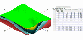
This program creates a tabular report by computing the total volume and/or mass for each formation as a function of the relative depth/elevation, computed from a stratigraphy model built from grid surfaces.
! This program requires that you have already created the stratigraphy model (and the component grid models), to be used for the computations.
See also
Solid Volumetrics for computations based on a stratigraphic solid model.
Feature Level: RockWorks Standard and higher
Menu Options
Step-by-Step Summary
- Stratigraphy Volumetrics
Click this tab to define the content of the volume report.
- Intervals: These settings will define for the program the total elevation range and the sampling intervals for the volume report. These are defined in your output units.
- Top Elevation: Enter the uppermost elevation to be included in the report.
- Base Elevation: Enter the lowermost elevation to be included in the report.
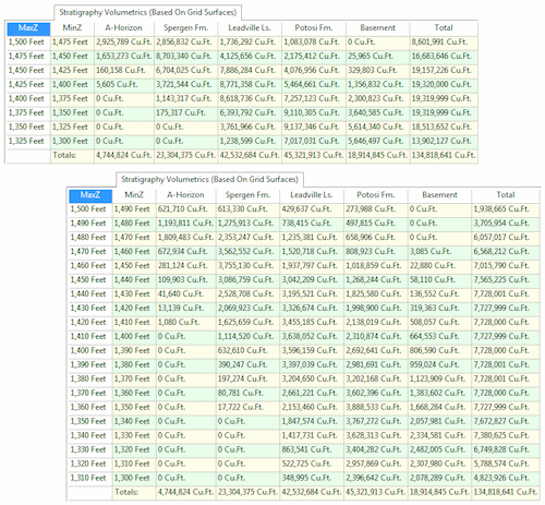
- Interval: Enter the sampling interval for the volume report. For example, if you enter "25", volume summaries will be generated every 25 feet or meters from the top elevation to the base. If you enter "10", volume summaries would be generated every 10 feet or meters from the top to the base. The vertical units are those specified in the Project Dimensions tab.
- Output Options: Use these settings to define what type of results will be included within the report.
- Volume: Results will be reported in the units you've defined in the Project Settings.
- Mass: Computations are based on the Density value declared in the current Stratigraphy Types Table which declare mass per cubic unit.
- Decimals: Specify the number of decimal places to be represented in the depth intervals in the report, and the volume or mass computations. Be sure this is adequate to represent your layers: if you've requested an Interval of 2.5 feet and you choose 0 decimal places, it will be difficult to discern the report's interval groupings.
- Output Options
Click this tab to define the output format(s) for the report. (More info)
- RwDat (RockWorks): Click in this button if you want the report generated in a RockWorks datasheet (.RwDat) format.
- CSV (Excel): Click in this button if you want the report generated in a CSV file format for use in Excel.
- TXT (Notepad): Click this if you want the report generated in a text (.txt) format.
- RTF (Word): Click this if you want the report generated in an RTF file format for use in Word.
- First, be sure that the volume and mass units you wish to output are defined in the Project Settings Units tab.
- Next, if you intend to include mass calculations, be sure the density values and units are defined in the Stratigraphy Types table.
- Access the RockWorks Borehole Manager program tab.
- If necessary, create the stratigraphic model for which the volumes are to be computed.
! This volume tool will not first create the stratigraphy model - it assumes the formation surfaces have already been interpolated and that they comply with the expected naming procedure.
- Select the Borehole Operations | Stratigraphy | Grid Volumetrics menu option.
- Enter the program settings as described above.
- Click the Continue button to proceed.
The program will load the stratigraphic surfaces, and determine the formations and compute their volume and/or mass for each requested interval. The volume report will be stored in the requested output format(s) and displayed as requested.
- You can adjust any of the program settings (spacing, etc.) and then click the Continue button again to regenerate the report.
The following examples illustrate volume reports at 25-foot and 10-foot intervals.
 Back to Stratigraphy Menu Summary

RockWare home page