RockWorks | Borehole Operations | Stratigraphy | Solid Volumetrics
This program:
- Reads an existing stratigraphy solid model (.RwMod file)
- Creates a tabular report by computing the total volume or mass for each formation as a function of the relative depth/elevation
! Note that the accuracy of these computations will be affected by the vertical spacing of the solid model nodes; the closer the spacing, the more accurate the volume computations.
See also
Grid Volumetrics for computations based on the original stratigraphic surface models.
Feature Level: RockWorks Standard and higher
Menu Options
Step-by-Step Summary
- Stratigraphy Volumetrics
- Stratigraphy Solid Model: Click to the right to browse for the name of and existing stratigraphic solid model (*.RwMod). The volume calculations will be based on this model. (Stratigraphy solid models are generated under the Stratigraphy | Layered Model option, under the Save As Solid Model check-box.)
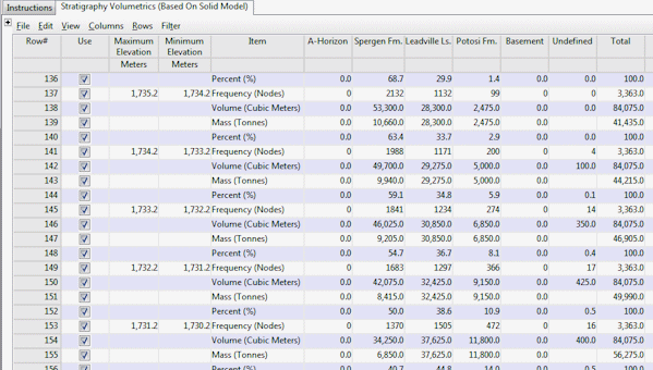
- Intervals: These options define the vertical portions of the model that are represented by each row within the volumetric report.
- Every Layer: Each row within the report will represent a layer of voxels within the solid model.
- User-Defined: Each row within the report will be based on a user-specified interval. For example, if the user specifies "50" for the interval, the program will list the volume of each stratigraphic unit contained within 50-unit-thick layers within the model. This is analogous to a mine "bench".
- Top-Elevation: Elevation at which to start the report. For example, if the user specifies 4500' for the top elevation and 50' for the interval, the first row within the report will show the volumetrics from 4500' to 4450' in elevation.
- Base-Elevation: Elevation at which to stop the report.
- Interval: Height represented by each row within the volumetric report.
- Output Options: These settings define what type of results will be included within the report.
- Nodes: Check this box to have the program list the number of nodes for each unit within each layer.
- Volume:Results will be reported in the cubic units you've defined in your Output Dimensions.
- Mass: Computations are based on the Density values declared in the current Stratigraphy Types Table which declare mass per cubic unit.
- Percent: Computations represent the percent of material within each layer (or bench). Note: This number represents percent by volume - not percent by mass.
- Decimals: Specify the number of decimal places to be represented in the depth intervals in the report, and the volume or mass computations. Be sure this is adequate to represent your layers: if the model's vertical node spacing is 1.25 feet and you choose 0 decimal places, it will be difficult to discern the report's interval groupings.
- Output Options
Click this tab to define the output format(s) for the report. (More info)
- RwDat (RockWorks): Click in this button if you want the report generated in a RockWorks datasheet (.RwDat) format.
- CSV (Excel): Click in this button if you want the report generated in a CSV file format for use in Excel.
- TXT (Notepad): Click in this button if you want the report generated in a text (.txt) format.
- RTF (Word): Click in this button if you want the report generated in an RTF file format for use in Word.
- First, be sure that the volume and mass units you wish to output are defined in the Project Settings Units tab.
- Next, if you intend to include mass calculations, be sure the density values and units are defined in the Stratigraphy Types table.
- If necessary, create the stratigraphic model for which the volumes are to be computed, using the Stratigraphy | Layered Model program. It is necessary that you turn on the Save As Solid Model option, so that the multiple stratigraphic surfaces are stored in a solid model (.RwMod) form. It is this .RwMod file that will be input into the volume calculator.
- Select the Borehole Operations | Stratigraphy | Solid Volumetrics menu option.
- Enter the program settings as described above.
- Click the Continue button to proceed.
The program will read the stratigraphy .RwMod file, match the node values to the units defined in the Stratigraphy Table, and compute the requested volume/mass/node/percent computations as requested. The volume report will be stored in the requested output format(s) and displayed as requested.
- You can adjust any of the program settings (model name, spacing) in the Options tab and then click the Continue button again to regenerate the report.
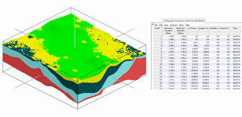
The following example depicts the output when all of the primary options (nodes, volume, mass, & percent) have been enabled.
! Note: Be warned that the node count that's reported will be high if you select User-Defined intervals and if the model's nodes are located at the interval boundaries - they'll get counted twice. (Volumes are not affected by this scenario and should be correct.)
 Back to Stratigraphy Menu Summary

RockWare home page