RockWorks | ModOps | Grid | Filters | Round
This program reads Z-values stored in a grid file and rounds them up or down to the user-declared Z-value rounding interval.
Menu Options
Step-by-Step Summary
- Grid Names
- Input Grid: Click to the right to browse for the name of the existing grid file (.RwGrd) that the program is to read and manipulate.
- Output Grid: Click to the right to enter the name to assign to the new grid file that the program will create, which results from the rounding operation.
- Interval
- Rounding Interval: Enter the Z-value interval to which grid nodes are to be rounded. For example, if you enter "10" and the Z-values represent feet, then all grid nodes will be rounded to the nearest 10-foot interval.
- 2D Grid Map
Check this box to display the output grid as a 2D map at this time.
Click this tab to set up the 2D map layers (bitmap, symbols, labels, line contours, color-filled contours, labeled cells, map border, etc.).
- 3D Grid Diagram
Check this box to display the output grid as a 3D surface at this time.
Click this tab to set up the 3D map layers (surface colors, images, reference cage, etc.).
! You can request both a 2D and 3D representation of the grid model.
- Be sure you have a RockWorks grid model (.RwGrd file) already created, for input into this program.
- Select the ModOps | Grid | Filters | Round menu option.
- Enter the requested menu settings, described above.
- Click the Process button to continue.
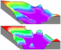
The program will load the input grid file, round each grid node Z-value to the nearest rounding interval, and store the results on disk under the output grid file name.
The requested diagram(s) will be displayed in a RockPlot2D tab and/or RockPlot3D tab in the Options window.
- You can adjust any of the settings in the Options window and then click the Process button again to regenerate the diagram(s).
- View / save / manipulate / export / print the diagram in the RockPlot2D or RockPlot3D window.
 Back to Grid Menu Summary

RockWare home page