RockWorks | ModOps | Grid | Filters | Minimum Area
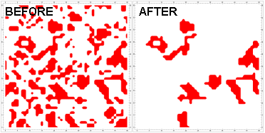
This program reads either a Boolean or a conventional grid model and evaluate contiguous cells that exceed a user-defined area. If the area of a group of contiguous cells is less than a user-defined threshold, the nodes will be set to zero. This provides a means for eliminating exploration targets that are too small.
Menu Options
Step-by-Step Summary
- Grid Names
- Input Grid: Click to the right to browse for the name of the existing grid model (.RwGrd) that is to be filtered. This can be a real number or Boolean grid model.
- Output Grid: Click to the right to type in a name for the filtered grid model the program will create.
- Cutoff Levels
- Minimum Value: Click here to type in the minimum Z value in the grid file to be considered. All higher values will be run through the filter. For example, if you are analyzing an input file that contains Boolean ("0" or "1") values, and you wish to compute areas only for the nodes assigned a "1", you could enter "1" here. Or, if you are analyzing a real number grid model, and you wish to compute areas only for nodes with geochemical values of 7.5 and higher, you would enter "7.5" here.
- Minimum Area: Click here to type in the minimum allowed area occupied by contiguous nodes with values greater than or equal to the declared minimum. This value will represent square units. For example, to filter out all material zones that occupy less than 1500 square feet, you would type in "1500".
- 2D Grid Map
Check this box to display the output grid as a 2D map at this time.
Click this tab to set up the 2D map layers (bitmap, symbols, labels, line contours, color-filled contours, labeled cells, map border, etc.).
- 3D Grid Diagram
Check this box to display the output grid as a 3D surface at this time.
Click this tab to set up the 3D map layers (surface colors, images, reference cage, etc.).
! You can request both a 2D and 3D representation of the grid model.
- Be sure you have a RockWorks grid model already created, for input into this program.
- Select the Grid | Filters | Minimum Area menu option.
- Enter the requested menu settings, described above.
- Click the Process button to continue.
The program will read the input model and determine the contiguous areas of values that exceed the declared minimum Z value. Those contiguous areas that fall below the declared minimum area will be re-assigned a Z value of zero. The resulting model will be stored on disk under the output grid file name.
The requested diagram(s) will be displayed in a RockPlot2D tab and/or RockPlot3D tab in the Options window.
- You can adjust any of the settings in the Options window and then click the Process button again to regenerate the diagram(s).
- View / save / manipulate / export / print the diagram in the RockPlot2D or RockPlot3D window.
 Back to Grid Menu Summary

RockWare home page