RockWorks | Graphics | Images | Google Earth | Float - Two Corner Points
This program:
- Reads a listing of data from the Datasheet Editor: image file names, elevations, and XY locations for the southwest and northeast corner points of each image.
- Creates a KML output file listing the images at those locations, floating at the defined elevations.
- Creates a KMZ (zip) output file, containing the KML and the image files.
- Loads the KMZ file in Google Earth.
See also: Floating Image Maps using Midpoints, Floating Image Animations
Menu Options
Step-by-Step Summary
- Data Columns: These prompts let RockWorks know which columns in the input datasheet contain the required data.
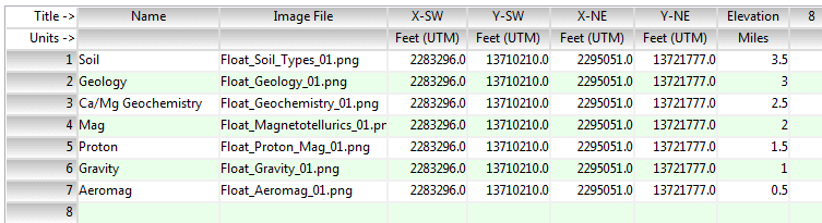
Click on an existing column name to select a different name from the drop-down list. See a sample data layout below.
- Name: Select the column that contains the text to label the image in the Google Earth side panel. If you don't have a separate name or title column, you can just set this to the Image File column.
- Image File: Select the column that contains the names of the images to be displayed in Google Earth. This program supports .BMP, .JPG, .PNG, .GIF, .TGA, and .TIF images.
Tip: use the File | Import | Create File List program to quickly create a list of specified file names.
- X SW: Column that contains the X coordinates for the southwest corner of the images.
These can be Eastings in meters or feet, decimal longitudes, etc. See Defining your Datasheet Coordinates for more information.
- Y SW: Column that contains the Y coordinates for the southwest corner of the images.
- X NE: Column that contains the X coordinates for the northeast corner of the images.
- Y NE: Column that contains the Y coordinates for the northeast corner of the images.
- Elevation: Column that contains the elevation at which the image is to be floated. These are absolute elevations, not distances above ground.
Be sure you've defined the elevation units in the datasheet.
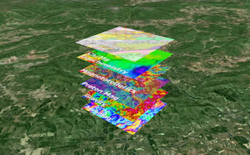
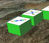
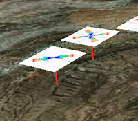
- Include Skirt: Insert a check here if the images are to include a "skirt" which extends from the floating image to the ground surface.
- Type: Choose a skirt type: Corner-to-Corner (left), Corners-to-Midpoint (middle), or Midpoint-to-Midpoint (right)
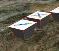
- Line Style: Choose the color and thickness (in pixels) for the skirt edges. Click on the color box to choose a different color.
- Fill Panels: Check this box if the skirt is to be filled with solid color. Click on the color box to choose a different color.
- Group Name: Type in the name to assign to the group of images, which will be displayed in the Google Earth data tree.
- Output Options: Click on this tab to define the output file and display settings.
- Output File Name
- Automatic: Choose this option to have RockWorks assign the name automatically. It will use the name of the current program plus a numeric suffix, plus the ".KMZ" file name extension.
- Manual: Click this option to type in your own file name. The extension is ".KMZ".
- Display output within Google Earth: Check this box if you want to display the output at this time in Google Earth.
! Note that the actual program which will be used to display the KMZ file is determined by your Windows settings.
- Use Custom View: If unchecked, the starting viewpoint for the images will be determined automatically. If checked you can set a custom view.
- Longitude, Latitude: Type in the longitude and latitude coordinates where the viewpoint will be.
- Heading: Type in the 0 to 360 degree bearing from the viewpoint to the images.
- Tilt: Type in the angle downward from the viewpoint to the images.
- Range: Enter the distance in meters from the viewpoint to the images.
- Access the RockWorks Datasheet program tab.
- Create a new datasheet and enter or import your image names and locations into the datasheet.
Or, open one of the sample files and replace that data with your own.
! Click the Example button to the left to load a sample file that is installed with the program.
Longitude and latitude coordinates must be in decimal format. If you're using another coordinate system, be sure you've specified the Units and the Projection Settings as appropriate. Be sure your Elevation column units are defined.
- Select the RockWorks | Graphics | Images | Google Earth | Float - Two Corner Points menu option.
- Enter the menu options as described above.
- Click the Process button to continue.
The program will create a KML file listing the raster images at the defined locations, at the specified sizes and elevations. It will create a KMZ file with the KML file and the image files. The Google Earth KML and KMZ file names will be assigned as you requested.
The resulting output will be displayed in Google Earth, if requested.
 Back to Image Menu Summary
"Google" is a trademark of Google Inc.

RockWare home page