"Land Grid Lease" descriptions are entered into the RockWorks datasheet using a Range, Township, Section, and description format.
RockWorks can do a variety of things with lease data:
- Create a map illustrating the lease blocks for output to RockPlot2D (Utilities | Maps | Oil Leases)
- Create a map illustrating the lease blocks for output to Google Earth (Utilities | Earth | Oil & Gas Leases).
- Compute X,Y location coordinates for the lease corners (Utilities | Coords | Public Land Survey -> XY).
All of these processes require that you have downloaded the RockWare Landbase, which functions as the reference land grid for the coordinate conversion.
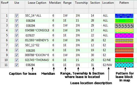
- Lease Caption: Optional, but recommended. Used to label the leases in maps. There is no limit to the amount of text for the caption. If you wish the text to be broken into more than one line when plotted on the map, insert a "^" character (upper case "6") where the break is to occur. See row 1, 4, 5, etc. in the above example.
- Meridian: Required. Must list the number for the Principal Meridian in which the Township is located. By defining this column type as a "Meridian" column you can double-click in a cell to bring up an interactive meridian selection map. See Changing Column Titles and Styles for details.
- Range: Required. Must list the Range number followed by the letter "E" or "e" or "W" or "w", with or without spaces separating the number and letter. The number must precede the letter. (The Range, Township, and Section declarations must be listed in separate columns.)
- Township: Required. Must list the Township number followed by the letter "N" or "n" or "S" or "s", with or without spaces separating the number and letter. The number must precede the letter.
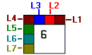
- Section: Required. Must list the Section number (1 - 36) in which the lease is located. If the lease spans more than one Section, you will need to create separate entries.
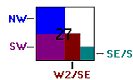
- Location: Required. The lease locations can be listed in either format below:
- Pattern: Optional, but recommended for Utilities maps, not used in Earth maps. Displays the actual pattern, with foreground and background colors, in which the lease block will be displayed in the map. You have the option of turning off the pattern or color fill if no pattern column is present. See Pattern Columns for more information.
- Maps_Oil_Leases.rwDat
- Be sure you've also downloaded the RockWare LandBase reference land grid.

RockWare home page