The required fields are displayed at the top of the Location table and in the Collar Coordinates tab. They can be typed in by hand, as described below, or imported from another source.
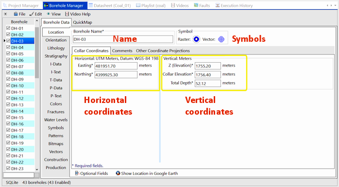
- Name: Type in a name for the borehole. This must be a unique name (multiple wells in a project cannot have the same name). This field is used to identify the borehole, and can be shown as a label in maps, logs, etc. The name can be comprised of numeric and/or alphabetic characters, up to 80 characters in length including spaces.
- Symbol: Click on the Symbol picture and select the vector symbol and color to be used to represent this well in borehole location maps.
- Raster Symbol: Click on the Raster Symbol picture and select the bitmap symbol to be used to represent this borehole in Google Earth maps.
- Horizontal Coordinates: These define the location of the hole on the ground.
! The default coordinate system and units - displayed on the Location tab itself and shown in yellow above - were defined when the project was created.
- Easting: Enter the Easting or X-coordinate for the borehole in the coordinate system and units shown.
If you don't now know the Easting coordinate - maybe you have well locations in longitude/latitude coordinates or PLSS (range/township/section) descriptions only - you can enter 0 at this time, enter the known coordinates in the Other Coordinate Projections tab, then compute the Easting from there.
- Northing: Enter the Northing or Y-coordinate for the borehole in the coordinate system and units shown.
As above, if you don't now know the Northing coordinate, you can enter 0 at this time, enter the known coordinates in the Other Coords tab, then compute the Northing from there.
- Vertical Coordinates
! The default units - displayed on the Location tab itself and shown in yellow above - were defined when the project was created.
- Z (Elevation): Type in the elevation at the top of the well, in the units shown.
- Collar Elevation: Enter here the elevation for the well collar or kelly bushing or well casing, in the units shown. If this is not known, set this to the same as the Z (Elevation) value.
! You can reference the depths in different database tables to either the ground elevaton or the collar elevation.
- Total Depth: Enter the total depth for the well, in the units shown. If the well is inclined or deviated, this should be the measured depth, not the true vertical depth.
 Back to Location Table

RockWare home page