RockWorks | Utilities | Coords | XY->Polar
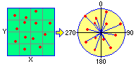
This program is used to translate X,Y locations in a Cartesian coordinate format to a polar coordinate format (bearing and distance) assuming a fixed reference point. The resulting coordinates are stored in two columns in the main datasheet.
Menu Options
Step-by-Step Summary
- Data Columns: Use these prompts to define the columns in the current datasheet which contain the input data, and to which the output coordinates are to be recorded.
- Input
- X (Easting): Select the name of the column in the datasheet that contains the existing X (Easting) Cartesian coordinates to be translated.
Be sure you define your coordinate system and units. See Defining your Datasheet Coordinates for more information.
- Y (Northing): Select the name of the column in the datasheet that contains the existing Y (Northing) Cartesian coordinates to be translated.
- Output
- Bearing: Select the name of the column in the current datasheet into which the computed bearing (0 to 360 degrees) are to be recorded. Be warned that any existing data in the columns will be overwritten!
- Distance: Select the name of the column in the current datasheet into which the computed distance measurements (in any units) are to be recorded. Any existing data in the columns will be overwritten!
- Conversion Parameters
- Origin: Use this tab to specify the X and Y Cartesian coordinates for the single point that will serve as the reference point for the coordinate translation.
- X (Easting): Type in the X or Easting coordinate for the origin reference point. The reference coordinate must be in the same units as the X and Y source coordinates.
- Y (Northing): Enter the Y or Northing coordinate for the origin reference point. The reference coordinate must be in the same units as the X and Y source coordinates.
- Decimals: Click on the Decimal item to specify the number of decimal places for the output distance and bearing measurements.
- Access the RockWorks Datasheet program tab.
- Create a new datasheet and enter or import the X and Y coordinates, in a Cartesian coordinate system, to be translated.
Or, open one of the sample files and replace that data with your own. See Data Layout for datasheet examples.
! Click the Example button at the top of the window to load a sample file that is installed with the program.
- Select the Utilities | Coords | XY -> Polar menu command.
- Enter the requested program settings, described above.
- Click the Continue button to proceed.
The program will convert the source X,Y coordinates to a polar format as specified and store them in the selected columns in the datasheet. The distance units will represent the same units as the original X and Y coordinates.
 Back to Coords Menu Summary

RockWare home page