RockWorks | Graphics | Animate | Google Earth Flyovers | Golf Ball Flight Simulation
This program:
- Reads a listing of data from the Datasheet: Starting XY locations and elevations ("tees") and ending XY locations and elevations ("pins").
- Creates a KML output file containing a series of parabolic flights along the listed route of point pairs.
- Creates a KMZ (zip) output file, containing the KML file with the tour.
- Loads the KMZ file in Google Earth.
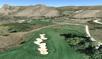
This differs from the simple forward-facing flyover by listing beginning and ending XYZ coordinates for each segment, and by following parabolic flights - like a golf ball's trajectory - rather than straight, point-to-point flights. Obviously, this works great to show off golf couses, but can also be used to move between any locations along an arced, rather than straight, path - airports, job sites, etc.
See also
Simple Flyovers - Forward Facing
Simple Flyovers - Virtual Tours
Feature Level: RockWorks Basic and higher
Menu Options
Step-by-Step Summary
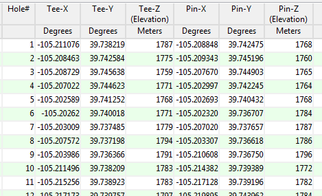
- Data Columns: These prompts tell RockWorks which columns in the current Datasheet contain the different input data fields. Click on an existing column name to select a different name from the drop-down list. See a sample data layout below.
- Hole ID: Column that contains the name for each flight segment. This could be a golf course hole number (as in this example) or other identifier ("DEN - SFO").
- Tee-X (Easting): Column that contains the X coordinates for the start of each flight segment (e.g. the golf tees).
These can be Eastings in meters or feet, decimal longitudes, etc. See Defining your Datasheet Coordinates for more information.
- Tee-Y (Northing): Column that contains the Y coordinate for the start of each flight segment.
- Tee-Z (Elevation): Column that contains the elevation for the start of each segment.
Be sure you've specified your elevation units.
- Pin-X (Easting): Column that contains the X coordinate for the end of each flight segment (e.g. the golf pin).
- Pin-Y (Northing): Column that contains the Y coordinates for the segment end.
- Pin-Z (Elevation): Column containing the elevations for the segment end.
- Tour Title: Type in a name for the flyover.
- Group Name: Type in the name to assign to the flyover, which will be displayed in the Google Earth data tree.
- Output Options: Click on this tab to define the output file and display settings.
- Output File Name
- Automatic: Choose this option to have RockWorks assign the name automatically. It will use the name of the current program plus a numeric suffix, plus the ".KMZ" file name extension.
- Manual: Click this option to type in your own file name. The extension is ".KMZ".
- Display output within Google Earth: Check this box if you want to display the output at this time in Google Earth.
! Note that the actual program which will be used to display the KMZ file is determined by your Windows settings.
- Use Custom View: If unchecked, the starting viewpoint for the images will be determined automatically. If checked you can set a custom view.
- Longitude, Latitude: Type in the longitude and latitude coordinates where the viewpoint will be.
- Heading: Type in the 0 to 360 degree bearing from the viewpoint to the flyover start.
- Tilt: Type in the angle downward from the viewpoint to the flyover start.
- Range: Enter the distance in meters from the viewpoint to the flyover.
- Access the RockWorks Datasheet program tab.
- Create a new datasheet and enter or import the tee and pin locations into the datasheet.
Or, open one of the sample files and replace that data with your own.
! Click the Example button at the top of the window to load a sample file that is installed with the program.
Longitude and latitude coordinates must be in decimal format. If you're using another coordinate system, be sure you've specified the Units and Projection Settings as appropriate.
- Select the RockWorks | Graphics | Animate | Google Earth Flyovers | Golf Ball Flight Simulation menu option.
- Enter the program settings as described above.
- Click the Continue button to proceed.
The program will create a KML file listing the flyover path along the designated segments. It will create a KMZ (zip) file containing the KML file. The Google Earth KML and KMZ file names will be assigned as you specified.
The resulting flyover will be displayed in Google Earth, if requested.
 Back to Animate Menu Summary
"Google" is a trademark of Google Inc.

RockWare home page