RockWorks | Borehole Operations | StripLogs | Surface Intersections
Use this program to calculate the XYZ location and measured depth along the hole, where all/enabled boreholes intersect an existing surface (.RwGrd file). The output is displayed in a RockWorks datasheet.
Notes:
- If the borehole never pierces the surface, it will display a "N/A" value.
- If the borehole intersects the surface at multiple locations, they will all be listed.
- The output units (feet or meters) will be those of your output project coordinates, even if the input depths and elevations are in a different system.
Feature Level: RockWorks Basic and higher
Menu Options
Step-by-Step Summary
- Options
- Grid Model: Click to the right to browse for the name of the existing RockWorks grid model (.RwGrd file) which represents the surface whose borehole intersections are to be calculated.
- All Boreholes / Enabled Boreholes: Click in one of these radio buttons to specify whether the intersection points are to be calculated for all holes in the Borehole Manager database, or only the enabled holes.
- Omit Non-Intersection Boreholes: Insert a check in this box if you want the program to omit boreholes from the output listing which never pierce the surface.
- Decimals: Enter how many decimal places are to be calculated for the output elevation (Z) coordinates and depths.
- Output Options
Click this tab to define the output format(s) for the report. (More info)
- RwDat (RockWorks): Click in this button if you want the report generated in a RockWorks datasheet (.RwDat) format.
- CSV (Excel): Click in this button if you want the report generated in a CSV file format for use in Excel.
- TXT (Notepad): Click in this button if you want the report generated in a text (.txt) format.
- RTF (Word): Click in this button if you want the report generated in an RTF file format for use in Word.
- Access the Borehole Manager program tab.
- If you don't want to run all of the boreholes through the calculator, be sure to enable only those to be processed.
- Select the Borehole Operations | StripLogs | Surface Intersections menu command.
- Enter the requested menu options, described above.
- Click the Continue button at the bottom of the window to continue.
The program will read the well location and downhole survey information for all holes or enabled holes (as requested) from the database. It will determine the downhole trace of each hole, and will calculate the X, Y, Z (elevation) coordinates and measured depth along the hole where each boring intersects the specified surface.
If the borehole is deviated and pierces the surface more than one time, the multiple points will be listed. If the borehole never intersects the surface, it will be noted with "n/a".
The results will be displayed in the requested output format(s).
- You can adjust any of the settings in the main Options tab to the left and click the Continue button to regenerate the report(s).
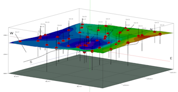
TIP: If you want to display the XYZ intersection points in space, as shown by the red spheres in the image at the top of this page, open the .RwDat file into the RockWorks Datasheet, and use the Utilities | 3D | Points program.
 Back to StripLogs Menu Summary

RockWare home page