
RockWorks | Borehole Operations | Striplogs | Endpoint Comparison
This program is used is used to generate a listing of the spatial relationships for the borehole endpoints. It is often used by drilling companies when comparing multiple, complex boreholes. The output from this program can be recorded in a variety of formats.
Feature Level: RockWorks Basic and higher
Menu Options
Step-by-Step Summary
- Report Contents: You can select as many computations as you wish by inserting checks in their check-boxes.
- Total Depths: Display the following total-depth information within the output datasheet:
A-TD: Total drilled length for borehole "A".
B-TD: Total drilled length for borehole "B"
- XYZ Coordinates: Display the following borehole endpoint coordinates within the output datasheet:
Ax: X-coordinate (easting) at base of borehole "A".
Ay: Y-coordinate (northing) at base of borehole "A".
Az: Z-coordinate (elevation) at base of borehole "A".
Bx: X-coordinate (easting) at base of borehole "B".
By: Y-coordinate (northing) at base of borehole "B".
Bz: Z-coordinate (elevation) at base of borehole "B".
- Azimuths & Inclinations: Display the following borehole endpoint spatial relationships within the datasheet:
A->B Azimuth: Bearing (in degrees) from base of borehole "A" to base of borehole "B".
A->B Inclination: Inclination angle (in degrees) from base of borehole "A" to base of borehole "B".
B->A Azimuth: Bearing (in degrees) from base of borehole "B" to base of borehole "A".
B->A Inclination: Inclination angle (in degrees) from base of borehole "B" to base of borehole "A".
- Distances: Display the following distances between the borehole endpoints within the datasheet:
3D-Distance: Three-dimensional space distance from the base of borehole "A" to the base of borehole "B".
Horizontal Distance: Horizontal ("as the crow flies") distance from the base of borehole "A" to the base of borehole "B".
Vertical Distance: Vertical distance (elevation difference) between the base of borehole "A" to the base of borehole "B".
- Relative Offsets: Display the following offsets between the base of borehole "A" and the base of borehole "B" within the datasheet.
A->B X-Offset: East/west offset of borehole "B" relative to borehole "A".
A->B Y-Offset: North/south offset of borehole "B" relative to borehole "A".
A->B Z-Offset: Elevation offset of borehole "B" relative to borehole "A".
B->A X-Offset: East/west offset of borehole "A" relative to borehole "B".
B->A Y-Offset: North/south offset of borehole "A" relative to borehole "B".
B->A Z-Offset: Elevation offset of borehole "A" relative to borehole "B".
- Midpoints: Display the following coordinates for a point that lies midway between the base of borehole "A" and the base of borehole "B" within the datasheet.
Mid-X: X-coordinate (easting) of point that lies midway between the base of borehole "A" and the base of borehole "B".
Mid-Y: Y-coordinate (northing) of point that lies midway between the base of borehole "A" and the base of borehole "B".
Mid-Z: Z-coordinate (elevation) of point that lies midway between the base of borehole "A" and the base of borehole "B".
- Decimal Places: Number of decimals places use when listing results within the output datasheet.
- Output Options
Click this tab to define the output format(s) for the report. (More info)
- RwDat (RockWorks): Click in this button if you want the report generated in a RockWorks datasheet (.RwDat) format.
- CSV (Excel): Click in this button if you want the report generated in a CSV file format for use in Excel.
- TXT (Notepad): Click in this button if you want the report generated in a text (.txt) format.
- RTF (Word): Click in this button if you want the report generated in an RTF file format for use in Word.
- Access the Borehole Manager program tab.
- Enter/import your data into the Borehole Manager, if necessary.
- Verify that the names of the boreholes to be included in the computations are enabled (the check-boxes to the left of the borehole names are checked).
- Select the Borehole Manager | StripLogs | Endpoint Comparison menu option.
- Establish the computation options, as described above.
- Click the Continue button to proceed with the calculations.
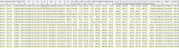
The program will determine the true 3D location for each active borehole's ending point, and will perform the requested computations. The results will be recorded in the requested output format(s). The example below shows all of the possible columns.
- See the Edit | Adjust Total Depths option if you are not certain that the borehole Total Depth fields (Location table) match the lowest recorded data value for the boreholes.
- Use the File | Save menu to save the report as an RwDat file, or the File | Export menu to export to another format.
 Back to StripLogs Menu Summary

RockWare home page