RockPlot2D | File | Export | ESRI Shape Files
or
RockWorks | Graphics | 2D | Export | Shape
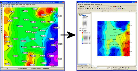
This program is used to export the active layers of the current RockPlot2D display to an ESRI Shape file format, for use with ArcGIS. Three shape types are exported:
- Points: Circles, Symbols, Text
- Polylines: Lines, Polylines (such as contour lines), Arrows
- Polygons: Color contours, polygons
Other items in the RockPlot2D graphic will be ignored. It is highly recommended to limit the kinds of data that are being exported at any one time - use RockPlot2D's layers pane to enable/disable the items to be exported/not exported.
Menu Options
Step-by-Step Summary
- Input File
- RockPlot2D File: (in the Graphics | 2D Tools | Export | Shape program only) Click here to select the name of the existing Rw2D file to be exported to Shapefile format. This file must have already been saved in the RockPlot2D window. See Saving RockPlot2D Images.
- Options:
- Destination:
- Folder: Click here to browse for the name of the folder into which the Shape files (.SHP, .SHX, .DBF) will be written.
! This may not automatically default to your project folder, so be sure to click this item to browse for the desired destination folder.
- Root Name: Click here to enter the "root" name for the Shape file layers you activate below. This name will be added to the front of the layer names you define below. See the Layers, below, for examples.
- Point Layer: Insert a check here to create Shape files for all Circles, Symbols, and Text in the active layers in the RockPlot 2D view.
- Point Layer Name: Click here to enter the name for the Point Shape files to be generated. For example, if you had entered "isopach" as the Root Name, above, and "point" for the Point Layer Name, the following Shape files would be generated: isopach_point.shp, isopach_point.shx, and isopach_point.dbf
- Polyline Layer: Insert a check here to create Shape files for all lines, polylines, and arrows in the active layers in the RockPlot2D view.
- Polyline Layer Name: Click here to enter the name for the Polyline Shape files to be generated. For example, if you had entered "isopach" as the Root Name, above, and "polyline" for the Polyline Layer Name, the following Shape files would be generated: isopach_polyline.shp, isopach_polyline.shx, isopach_polyline.dbf
- Include Polyline Z (Elevation) Values: Check this box to include Z values (elevation, isopach thickness, etc.) for the polylines. For example, if you were exporting contour polylines and wish to maintain their elevation values, you would enable the "Include Z" option.
- Polygon Layer: Insert a check here to create Shape files for all polygons and color contours in the active layers in the RockPlot2D view.
- Polygon Layer Name: Click here to enter the name for the Polygon Shape files to be generated. For example, if you had entered "isopach" as the Root Name, above, and "polygon" for the Polygon Layer Name, the following Shape files would be generated: isopach_polygon.shp, isopach_polygon.shx, isopach_polygon.dbf
- Include Polygon Z (Elevation) Values: Check this box to include Z values (elevation, isopach thickness, etc.) for the polygons. For example, if you were exporting contour polygons and wish to maintain their elevation values, you would enable the "Include Z" option.
- If necessary, open the Rw2D file you wish to export (see Opening Plot Files) or save the current plot if it's untitled (see Saving RockPlot2D Images).
- Use the layers pane to disable any layers you don't want to export.
- Select the File | Export | ESRI Shape Files command from the RockPlot2D menu.
- Enter the requested information in the displayed program window, as described above.
- Click the Process button when you are ready to continue.
These files can be added to an ArcMap view.
 Back to RockPlot2D Export menu
Back to Graphics Menu Summary

RockWare home page