RockPlot2D | File | Append
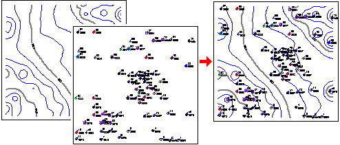
The Append command in the RockPlot2D File menu is used to add the contents of a RockPlot2D file (*.Rw2D) onto a diagram displayed on the screen, thereby combining the two. This is a handy way to combine, for example, project contours with a reference base map.
This is the same process as the Utilities | Grafix | 2D Utilities | Append tool.
Tips on Appending Files
- One of the most important concepts in combining 2D plot files is that the two maps or diagrams must occupy the same coordinates in space in order for them to overlay correctly. Some examples:
- You can overlay a RockWorks point map of a data set with a contour map created of the same data set since they have the same x and y coordinate range.
- You cannot overlay a map of Oklahoma onto a map of Maine since their real world coordinates don't coincide.
- You cannot overlay a point map of Colorado cities that is in longitude and latitude coordinates onto a contour map of Colorado that is in UTM coordinates - again, the coordinates don't coincide.
- You can use the coordinate display at the bottom of the RockPlot2D window to get an idea of the coordinate range of any diagram. Just move the mouse pointer around the RockPlot2D window and note the change in the coordinate listing.
- You can use the RockPlot2D | Utilities | Rescale command to rescale a map or diagram to a different coordinate range.
- You can use the RockPlot2D | Utilities | Convert Map Coordinates to reproject a map to a different coordinate system.
- Open: In the dialog box, select the name of the existing Rw2D plot file that is to be added on top of the displayed image, and choose OK.
Follow these steps to combine two RockPlot2D images.
- Open or create the diagram that is to be the bottom layer (e.g. the diagram to which the first is to be appended) or click in that diagram’s window if it’s already open.
- With that bottom-layer image active, select its File | Append menu command.
- Browse for the name of the Rw2D file to be appended to the top of this image, and click OK.
- The program will plot the contents of the selected file on top of the existing image.
- If you wish to save this new, combined version, use the File | Save As command.
- Use the layers pane to change the "stacking order" of the map items if necessary: just right-click on a layer name and choose Bring to Front or Send to Back.
 Back to Managing RockPlot2D Files

RockWare home page