Borehole Operations | Maps | Google Earth Borehole Map - Simple
Use this program to display your borehole locations with symbols in Google Earth. The program will use the Google Earth Icon symbol currently displayed in the Location tab for each hole. You can also include simple borehole labels.
Translation of your borehole coordinates to longitude/latitude will occur automatically. Google Earth is not included with RockWorks and is installed separately.
See also
Creating a Borehole Location Map in Google Earth (Advanced) for maps with more labeling options.
Feature Level: RockWorks Basic and higher
Menu Options
Step-by-Step Instructions
- Symbol Label Options:
-
- Include Labels: Insert a check here to include borehole ID labels in the output map. They will be hard-wired to white and a fixed size.
- Group Name: Click on this tab to type in a name for the group heading for the symbol map, which will be displayed in Google Earth.
- Output Options: Click on this tab to define the output file and display settings.
- Output File Name
- Automatic: Click this option to have RockWorks assign a name to the KMZ file which will be generated for display in Google Earth.
- Manual: Click this option to type in your own file name. The extension is ".KMZ".
- Display output within Google Earth: Check this box if you want to display the output at this time in Google Earth.
- Use Custom View: If unchecked, the starting viewpoint for the map will be determined automatically. If checked you can set a custom view.
- Longitude, Latitude: Type in the longitude and latitude coordinates where the viewpoint will be.
- Heading: Type in the 0 to 360 degree bearing from the viewpoint to the map.
- Tilt: Type in the angle downward from the viewpoint to the map.
- Range: Type in the distance in meters above the map for the starting viewpoint.
- Access the Borehole Manager program tab.
- Enter/import your data into the Borehole Manager database. (More info)
- Select the Maps | Google Earth Borehole Map - Simple menu option.
- Enter the program settings as described above.
- Click the Continue button to create the map.
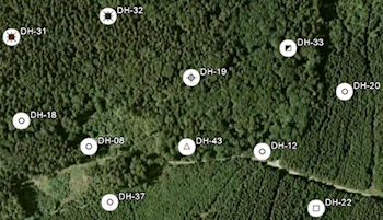
The program will create a map of the well locations, reading the location information and symbol style from the Location tabs. Requested borehole ID labels will be pulled from the Location table. It will create a KMZ (zip) file containing the KML file.
The resulting map will be displayed in Google Earth, if requested.
"Google" is a trademark of Google Inc.
 Back to Map menu - Summary

RockWare home page