These files are used to define image names and their coordinates for display as 3-dimensional panels in RockPlot3D. RockWorks also contains tools for sampling X/Y/Z/Color information from the images, and for interpolating the color data into a solid model.
These programs require 8 columns of information: The names of the images to be displayed in the 3D panels, their layer name, and the X, Y, and Z coordinates for the lower-left and upper-right corners of the raster image. See Raster Formats for supported bitmap file types.
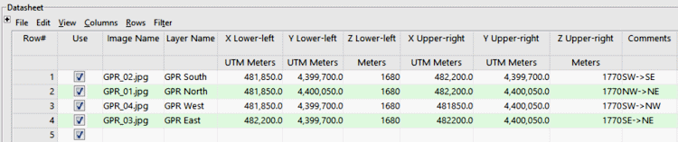
- File Name: Required. The images to be displayed in the panels must be in one of the graphic formats listed above. They must reside in the current project folder, along with the rwDat file in which they are listed.
- Layer Name: Required. This will be used to label the panel in RockPlot3D.
- Lower-left X, Y, Z: Required. These assign easting, northing and elevation coordinates to the lower-left corner of the bitmap, so that it can be placed in 3-D space in RockPlot3D. Be sure to define your coordinate system (for X and Y) and units (all). See Defining your Datasheet Coordinates for more information.
- Upper-right X, Y, Z: Required. These assign easting, northing, and elevation coordinates to the upper-right corner of the bitmap.
- Images_Vertical_Multiple_GPR.RwDat
- Images_Vertical_Multiple_HandDrawnSec.RwDat

RockWare home page