Claim locations can be entered into the RockWorks datasheet using X and Y (Easting and Northing) coordinates for each claim corner, with 4 corners total. RockWorks can create a 2D map illustrating the claim blocks (Utilities | Maps | Claim Map), a Google Earth map illustrating the blocks (Utilities | Earth | Mining Claims), and it can compute the area encompassed by the claim for recording back to the datasheet (Utilities | Survey | Mning Claims Area).
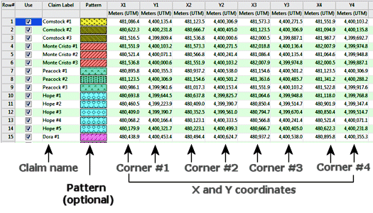
- Claim Name: Optional, but recommended. Used to label the claims in maps.
- Pattern: Optional. Displays the actual pattern, with foreground and background colors, in which the claim block can be displayed in the map. You have the option of turning off the pattern or color fill if no pattern column is present. See Pattern Columns for more information.
- X1, Y1, X2, Y2, X3, Y3, X4, Y4: Required. Must list the coordinates for the corners of the claim blocks. Be sure to specify the coordinate system and units represented.
- Earth_Mining_Claims.rwdat - example for the Utilities | Maps | Mining Claims, Earth | Mining Claims, and Survey | Mining Claim Area programs.

RockWare home page