Borehole Manager | Edit | Coordinate Converter to Easting/Northing
Use this program to compute borehole Eastings and Northings (in the Location table's Collar Coordinates tab) from coordinates currently stored in the Other Coordinate Projections tab. RockWorks will convert the coordinates based on the project's current coordinate system.
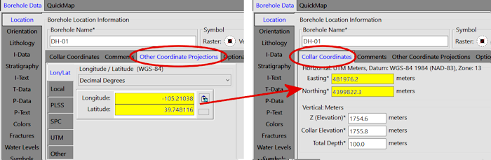
Example: Let's say you have only longitude and latitude coordinates for your borehole locations, which you have imported into and are displayed in the Other Coordinate Projections tab. The Collar Coordinates tab shows your coordinate system (set up when you created your project) as UTM meters, WGS-84 (NAD-83), Zone 13. But, the Eastings and Northings are all set to "0". Since it's the Collar Coordinates which are required for mapping and modeling, you can use this Coordinate Converter program to compute these Eastings and Northings in bulk from the available lon/lat values.
! This program offers an initial database backup, and the option to convert only the holes where the Easting and Northing are not set (e.g. values of "0").
See also
The To Easting/Northing button on the Other Coords data tab for coordinate calculations for individual holes.
Feature Level: RockWorks Basic and higher
Menu Options
Step-by-Step Summary
- Convert from Other Coordinate Projection: Use these settings to select which of the existing Other Coordinate Projection fields you wish to use to compute the Collar Coordinates Eastings and Northings.
- Longitude/Latitude: Select this option to compute borehole Eastings and Northings from Longitude and Latitude coordinates.
- Local Coordinates: Select this option to compute borehole Eastings and Northings from Local Coordinates.
- PLSS: Select this option to compute borehole Eastings and Northings from PLSS (Public Land Survey System) locations.
! This option requires that you have downloaded and installed the RockWare LandBase.
- State Plane: Select this option to compute borehole Eastings and Northings from State Plane coordinates. Be sure the State Plane Zone is correctly defined; if not, click on the Zone button and choose the Zone for these coordinates.
- UTM: Select this option to compute borehole Eastings and Northings from UTM coordinates. Be sure the UTM Datum and Zone are correctly defined here. If not, click the Datum button to select the Datum for these coordinates. Click on the Zone button to select the Zone for these coordinates.
- Other: Click in this radio button to compute borehole Eastings and Northings from coordinates which represent a custom projection. More info
- Update Current Project Easting/Northing Values: Here you will see the coordinate system currently established for your project database. This is the system to which the Other Coordinates will be converted. This display is for your reference only, you cannot change the current project coordinates here.
- Boreholes to Process:
- Do All Boreholes: Select this option to perform the coordinate translation on all boreholes in the project.
- Do Only Enabled Boreholes: Select this option to perform the coordinate translation on all active boreholes.
- Only where Easting/Northing are not set: Check this box if the coordinate conversion is to be done for those holes (all or enabled as specified above) whose Easting and Northing coordinates are currently set to 0,0. This is a means of protecting existing, valid, coordinates.
- Access the Borehole Manager program tab.
- If necessary, disable any holes whose Collar Coordinates are not to be computed.
- Select the Edit | Coordinate Converter to Easting/Northing menu option.
- Enter the requested menu options, described above.
- Click the Continue button to proceed.
- When prompted if you wish to first make a backup copy of the current database, choose Yes or No as you wish. (We recommend Yes.)
- If a backup was requested, RockWorks will notify you of the name and location of the backup archive - click OK to continue.
The program will read the selected coordinates listed in the Other Coordinate Projections tab for the requested boreholes and translate them to the current project coordinate system, recording the new coordinates in the Collar Coordinates tab Easting and Northing fields. It will display a window notifying you of the number of holes which were converted.

RockWare home page