There are several ways to note missing stratigraphic formation data in the Borehole Manager Stratigraphy table. The method you use will affect, at its most basic, how 2D strip logs and log sections are displayed. It will also affect how stratigraphic surface maps, thickness maps, profiles, fence diagrams, and 3D models are created.
See also: Stratigraphy Rules
The methods that are discussed here are:
Zero-Thickness Formations
Omitted Formations
Missing Formation Base - Deepest Unit
Missing Formation Bases - All Units
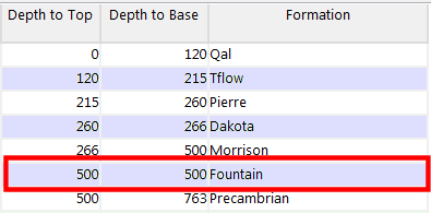
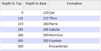
One method of noting a missing formation is to list the unit in proper sequence in the hole, and assign the formation top and base the same depth, resulting in a thickness of zero (e.g. pinched out).
Tip: Use the Stratigraphy | Fill In Missing Stratigraphy menu option for an automatic way of entering zero-thickness formations.
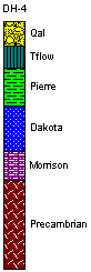
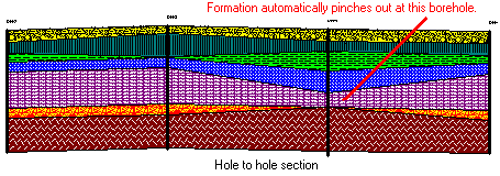
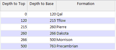
Another way to note "no data" is to omit the formation name altogether. In this example, the Fountain formation is not listed at all.
Tip: Use the Stratigraphy Rules - Insert Missing Units for an automatic method of inserting zero-thickness units in proper sequence during processing. RockWorks won't actually add any data to your database, but will make these inferences in the background using your existing data, prior to diagram creation.
Missing Formation Base - Deepest Unit
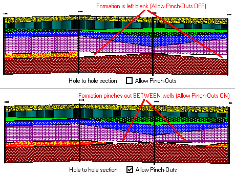
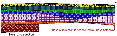
Another common scenario occurs when a borehole ends in the middle of a unit, challenging the geologist to decide whether to list the base of the boring as the base of the formation (not entirely correct) or to leave it blank. RockWorks permits you to leave a formation base blank, as shown below:
This will result in the following consequences:
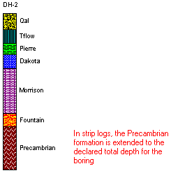
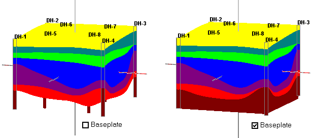
Tip: Use the Stratigraphy Rules - Infer Partial Units for an automatic method of inserting unit tops or bases during processing. RockWorks won't actually add any data to your database, but will make these inferences in the background using your existing data, prior to diagram creation.
Missing Formation Tops and/or Bases - Multiple Units
If you are entering/importing stratigraphic data that contains tops only, or a mix of tops and bases with a lot of missing data, you can make this work also.
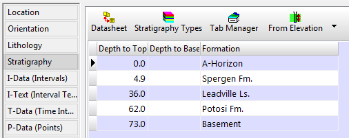
Striplogs will now plot stratigraphic data when only the tops are defined. Use the Stratigraphy Rules - Infer Partial Units options to automatically set the lower depths to the top-depths for the next lowest unit. The depth to the base of the lowest entry is assumed to be equal to the TD (total depth) for the borehole.
See also
![]()