RockWorks | Borehole Manager | Striplogs | Fill In Missing Stratigraphy
Use this data tool to have the program compare the formation listings for each enabled borehole against the formations listed in the Stratigraphy Types Table, and automatically fill in any missing formations above the borehole bases. In so doing, it will set those new formations to zero-thickness, squeezed in between any existing formations. The units won't show up in logs, but they will add control to the modeling process.
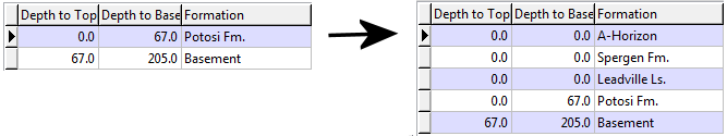
Upper units will pinch out:
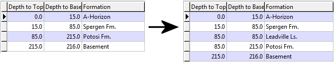
The middle Leadville unit will pinch out:
! Formations below the base of the borehole will not be added.
! If the first formation's Depth to Top field is blank, no units above that formation will be added.
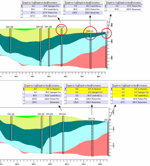
Why would you want to do this? As described in the Missing Formations topic, entering a formation where it "should" be with a thickness of zero offers the program more control for structural pinchouts than just leaving the formation out of the listing. The following examples offer an illustration - take note of the three boreholes on the right edge of the cross-section. In the upper example, the missing formations are simply omitted from the data listing. When RockWorks creates surfaces to represent these units, there is no control in that area, so there are abrupt edges. In the lower example, the missing formations are entered with zero thickness, and better pinchouts result.
Menu Options
Step-by-Step Summary
RockWorks will read the stratigraphy listing for each borehole and determine any formations above the borehole base that are not present. Missing formations will be inserted, with their top equal to the base of the formation above, and their base equal to the top of the formation below (zero thickness). If the units are at the top of the log, the depths will start at zero.
See Also: Stratigraphy Rules for other automated methods of inserting missing formations.
![]() Back to StripLogs Menu Summary
Back to StripLogs Menu Summary
![]()