RockWorks | Utilities | EarthApps | Extract | Polylines - Multiple (One File per Polyline)
This program:
- Reads a listing of polyline (path) vertex coordinates for multiple polylines that have been copied or saved in Google Earth.
- Extracts the coordinates from the Google Earth KML structure, converting the coordinates if requested.
- Stores the X, Y, and elevation coordinates in individual RwDat files.
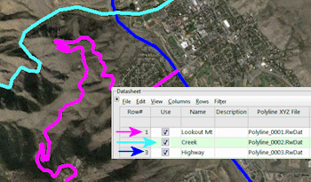
- Lists those RwDat file names in the datasheet.
Menu Options
Step-by-Step Instructions
Menu Options
- Input: Use these settings to define the input for the polyline data.
- Windows Clipboard: Choose this option if you have copied the polylines in Google Earth.
- KML or KMZ File: Choose this option if you have saved the polylines in Google Earth, in a KML or KMZ file.
- Input File: Click to the right to browse for the KML or KMZ file containing the polylines to be brought into RockWorks.
- Output: Use these settings to determine the coordinate system and units in which you want the polyline vertices to be recorded within RockWorks.
- Horizontal (X,Y) Coordinates:
- Decimal Degrees: Select this option to list the coordinates in decimal longitude (X) and latitude (Y) degrees.
- Local Coordinate System: Select this option to list the coordinates in local feet or meters. Expand this heading to define:
- Origin Longitude: Click to the right to enter the decimal longitude coordinate at your local coordinate origin (0,0).
- Origin Latitude: Click to the right to enter the decimal latitude coordinate at your local coordinate origin (0,0).
- Units: Choose whether the local coordinates are to represent feet or meters.
- US State Plane: Select this option to list the coordinates in a State Plane coordinate system. Expand this heading to define:
- Zone: Click to the right to choose the State Plane Zone within which the coordinates are to be based.
- Units: Choose whether the State Plane coordinates are to represent feet or meters.
- Universal Transverse Mercator: Select this option to list the coordinates in a UTM coordinate system. Expand this heading to define:
- Datum: Click to the right to choose the UTM Datum
- Zone: Click to the right to choose the UTM Zone within which the coordinates are to be based.
- Units: Choose whether the UTM coordinates are to represent feet or meters.
- Vertical (Z) Units: Choose whether you want the elevations listed in Feet or Meters units.
Step-by-Step Summary
- In Google Earth, create the polylines (paths) that you wish to bring into RockWorks. Or, locate the path group that currently exists in your Saved Places listing.
- Right-click on the path group, and choose Copy from the pop-up menu.
Or, right-click on the path group, and choose Save Place As to save the locations in a KMZ file.
- Start up RockWorks if necessary.
- Access the Utilities program tab.
- Create a new datasheet if necessary.
- Select the RockWorks | Utilities | EarthApps | Extract | Polylines - Multiple (One File per Polygon) menu option.
- Enter the menu options as described above.
- Click the Process button to continue.
The program will scan the data in the clipboard or specified KML/KMZ file. It will perform any coordinate conversions which are requested, and record the vertex coordinates for each polyline in a separate .RwDat file, named with sequential numbers. The coordinate system and units will be displayed in the column headings and any coordinate reference data will be included in the metadata. It will then list these polyline file names in the Datasheet.
See also: Creating Easy Maps
 Back to Extract Map Summary
"Google" is a trademark of Google Inc.

RockWare home page