RockWorks | Borehole Manager | File | Export | Well Construction
Use this program to create a 3D Shapefile of your well construction data, with data attributes, for display and analysis in ESRI's ArcScene.
This tool differs from the RockPlot3D 3D Shapefile export of 3D logs in that the data attributes are maintained, so that you can gather information about the data item in ArcScene.
Feature Level: RockWorks Basic and higher
Menu Options
Step-by-Step Instructions
- Spatial Filter: Insert a check in this box at the top of the program window to activate a data filter based on spatial coordinates. Click this button to enter the filter settings. Click the Return to Previous Menu button when you are done entering the filter settings. (More info)
- Output Shapefile: Click here to type in a name to assign the Shapefile to be created. The exporter will also create the accompanying .SHX and .DBF files.
- Null Value: If any of the well construction intervals are missing the depth to top or base for the interval, RockWorks will store a null value for that depth. Use this prompt to define the null value to be used, such as "-999".
- Output Type:
- Polylines: Choose this output style if you wish to see the data as polylines.
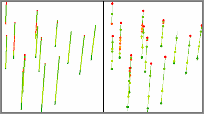
- Points (midpoint): Choose this output style to see the data as points. Compare the images below; the left image represents lithology data displayed as polylines in ArcScene. The right image represents lithology midpoints (on top of lithology polylines for reference).
- Access the RockWorks Borehole Manager program tab.
- Enter/import your data into the Borehole Manager database.
- Verify that the names of the boreholes containing data to be exported are enabled (the check-boxes to the left of the borehole names are checked).
- Select the File | Export | Well Construction menu option.
- Establish the export settings, as described above.
- Click the Continue button to proceed.
The program will read the selected data for the enabled borehole(s) and store the data in the requested output Shapefile, using the requested settings. Three files will be created: .SHP, SHX, and .DBF.
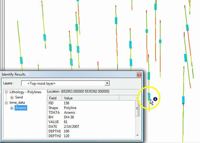
Use the Add Data command in ArcScene to bring the Shapefile data into the scene. You can access the layer's Properties to adjust colors and thicknesses. You can use the Inquire tool to retrieve information about any of the data. This example shows lithology data with T-Data intervals, as separate layers in ArcScene, with the Inquire tool displaying the available information.
 Back to Export Data
"ArcScene" is a trademark of ESRI Inc.

RockWare home page