
RockWorks | Utilities | Survey | Setup XY Stations
This program is used to create a new set of X,Y coordinates based on a single user-entered XYZ coordinate point, a known grid-based station arrangement, and a user-entered spacing.
Menu Options
Step-by-Step Summary
Menu Options
- Data Columns
- Output: Use these prompts to specify the data columns into which the data are to be recorded. Any existing data here will be overwritten.
- X: Select from the drop-down list the name of the column in the datasheet into which the computed X coordinates are to be listed.
- Y: Select the column into which the computed Y coordinates are to be listed.
- ID: Select the column in the datasheet into which the numeric ID will be listed.
- Options
- Coordinates: Use these prompts to define the starting coordinate location.
- X Minimum: Click on this and type in the known coordinate for the westernmost station. These coordinates can be in local units (feet, meters, etc.) or in global units (UTM, decimal degrees) as long as the units match the spacing units, below.
- X Maximum: Type in the known coordinate for the easternmost station.
- X-Spacing: Enter the regular spacing, in your X,Y units, for the stations along the X axis.
- Y Minimum: Type in the the known coordinate for the southernmost station.
- Y Maximum: Type in the known coordinate for the northernmost station.
- Y-Spacing: Enter the regular spacing, in your X,Y units, for the stations along the Y axis.
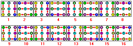
- Point Order: Use the diagrams to view the point ordering options; click in the radio button under the desired arrangement. This will determine the order in which the points are listed in the datasheet.
-
- Datasheet Starting row: Type here the number of the row in the datasheet into which the coordinate listing is to be started. The number of rows that will be required will correspond to the starting-to-ending coordinate range and the desired spacing.
- Decimals: Enter here the number of decimal places to be represented in the computed X and Y coordinates.
- Access the RockWorks Datasheet program tab.
- Create a new blank datasheet using the File | New | Blank menu option. Or create a new datasheet using a data template which has the X, Y, and ID columns already defined (File | New | Use Template).
- Select the Survey | Setup XY Stations menu option.
- Enter the menu settings, desribed above.
- Click the Continue button to proceed.
The program will create a grid of X,Y stations based on the requested minimum and maximum coordinates and spacings. The coordinates will be listed with ID's using the requested point order, in the declared starting row in the datasheet.
Tip: Once the program has computed the X,Y coordinates for the stations, assign the coordinate system and units, and select a symbol and color for each station. Then, you can create a simple point map of the locations using Map | Point Symbols.
 Back to Survey Menu Summary

RockWare home page