![]()
The Text Attributes window is used to define or to modify the location, size, layer, and appearance for map or diagram text. This window is displayed when you edit an existing text item or insert a new text item into a map or diagram.
Appearance Options
- Caption: This is the text to be displayed in the map or diagram. The text you enter will not wrap to multiple lines.
- Font Settings
- Font: Here you can change the font to any of those installed on your system, for this particular text item. The default font type is defined in the Preferences | Program Settings window.
- Size: The size that's displayed represents actual diagram or map units for the height of the characters.
! This is not how the font size is established back in the RockWorks menu; the program translates a relative font size to an actual size in map units as the diagram is being generated.
For example, if you see a size of "24.5", that means the text height is 24.5 map/diagram units. You can make the text larger or smaller by increasing or decreasing this value.- Color: Click on the Color box to change the color for the text.
- Angle: Horizontal text is set to an angle of "90." An angle of "0" will display the text vertically, reading upward. An angle of "180" will display the text vertically, reading downward. You can enter any integer value for the angle.
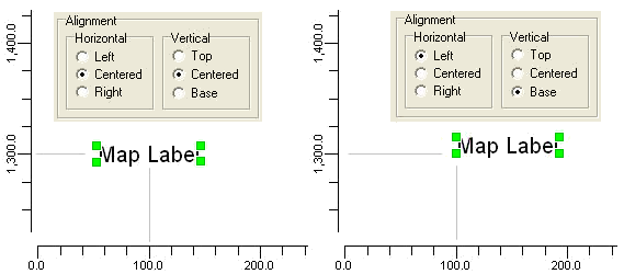
- Alignment: These settings will determine how the text will be displayed in relation to the location coordinates, defined below. For example, if you set the text to be horizontally and vertically centered, then the center of the text block will be placed at the location coordinates you define. Or, if you set the text to left and bottom alignment, then the lower-left corner of the text block will be placed at the location coordinate you define.
- Background: Choose whether the text block is to have a transparent background, so that any background image will show through, or an opaque background. If you choose Opaque, click on the color box to choose the background color.
Location Options
- Layer: Use this setting to select the layer to which the text is to be associated. See Working with Layers for more information.
- Location: The X (Easting) and Y (Northing) coordinates define the map location for the text.
- How the text is placed at these coordinates depends on the Alignment settings, above.
- The location of the text can also be changed by clicking and dragging on the plot window itself; see Editing Graphics for details.
- Copy X and Y Coordinates to Clipboard: Click this button to copy the text block's location coordinates to the Windows clipboard, for pasting elsewhere.
General Options
- Visible: Insert a check in this box for the text to be visible in the drawing or map. Remove the check-mark to hide the text.
![]() Back to Editing Tools
Back to Editing Tools
![]()