RockPlot2D | Utilities | Rescale
or
RockWorks | Graphics | 2D Tools | Rescale
This program is used to rescale X,Y location coordinates in a graphic image using either of these methods:
- Using new origin coordinates and scaling multipliers. (Coordinates may be rescaled differently in the X and the Y directions.)
- Using new coordinates entered for one or more boundary edges.
Menu Options
Step-by-Step Summary
Tips
- Input File (Graphics menu only): Click to the right to browse for the existing Rw2D file to be rescaled.
- Options
- Type of Rescaling: Choose one of the following, and establish the necessary settings:
- Origin & Scale: Use this method if you want to shift the coordinates of an existing map or diagram by assigning the plot file a new "origin" (southwest corner X,Y coordinates). This method also permits you to rescale the axes using a constant value, such as to divide the range of each axis by a factor of 100. You can set the origin and rescaling factors independently for each axis.
- X-Origin: Type in the coordinate to become the new minimum X in the rescaled image. You can set this to 0 or to any arbitrary value, or you can type in the existing minimum X coordinate if known.
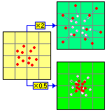
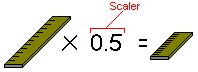
- X-Scalar: All x-coordinates will be multiplied by this number. To increase the X-axis dimensions, use a number greater than 1 (e.g. 2.0 will double the dimension). To reduce the extent of the X-axis, use a number less than 1 (e.g. 0.5 will decrease the dimension by 2x).
-
- Y-Origin: Type in the coordinate to become the new minimum Y in the rescaled image. You can set this to any real number value, or you can type in the existing minimum Y coordinate if known.
- Y-Scalar: All y-coordinates will be divided by this number. See the information above for X-Scalar.
- Min/Max Coordinates: Use this method to simply define new coordinates for one or more axes.
- Minimum Easting: Type in the coordinates to represent the west or left side of the map or diagram.
- Minimum Northing: Type in the coordinate to represent the south or bottom edge of the map or diagram.
- Maximum Easting: Type in the coordinate to represent the east or right edge of the map or diagram.
- Maximum Northing: Type in the coordinate to represent the north or top edge of the map or diagram.
- Output Options
- Save Output File: Check this to assign a name for the map in advance, rather than displaying it as Untitled.
- Automatic: Choose this option to have RockWorks assign the name automatically. It will use the name of the current program plus a numeric suffix, plus the ".Rw2D" file name extension.
- Manual: Choose this option to type in a name of your own for this file.
- Display Output: Check this option to have the resulting map displayed in RockPlot2D once it is created.
- If necessary, open the map or diagram to be rescaled (see Opening Plot Files) or click in the current RockPlot2D window containing that image and select the RockPlot2D Utilities | Rescale menu command.
- OR -
Select the RockWorks | Graphics | 2D Tools | Rescale menu option.
- Enter the input and output file names and select the desired rescaling option, as described above.
- Click the Process button to continue.
The program will shift and/or rescale the map as requested.
 Back to Manipulating RockPlot2D Files
Back to Graphics Menu Summary

RockWare home page