Insert a check in this option to activate a data filter based on rock type.
Click on this tab to set up the G value filter.
- Limit Input to Selected G Values: Enter the minimum and maximum "G" values to be exported. These values are assigned to the rock types in the Lithology Types Table. Only those data for the range of G values selected will be exported.
Insert a check in this box if you want the downhole data to be recorded at regular intervals.
Click on this tab to set up the resampling settings.
! If you do not activate resampling, the program will export the listed depths and the midpoints of each recorded lithologic interval.
- Resampling Interval: Enter the depth interval at which the lithology data is to be resampled. For example, if you want the lithology types to be sampled down each borehole every 10 feet, you would enter 10 for the Sample Interval. Be sure you don’t set this value too coarse for finely-spaced lithology types.
Click this tab to define the output format(s) for the exported data. You can select multiple options.
- RwDat (RockWorks): Check this option for the lithology data to be exported to a RockWorks datasheet (.RwDat) format. (More info)
- CSV (Excel): Check this option for the lithology data to be exported to a CSV file format for use in Excel. (More info)
- TXT (Notepad): Check this option for the lithology data to be exported to a text (.txt) format. (More info)
- RTF (Word): Check this option for the lithology data to be exported to an RTF file format for use in Word. (More info)
- SHP (ArcMap): Check this option for the lithology data to be exported to a Shapefile format. Click on this tab to set up the Shapefile options.
- Output (Shape) File:: Click to the right to type in a name to assign the Shapefile to be created. The exporter will also create the accompanying .SHX and .DBF files.
- Null Value: If any of your borehole lithology data are missing the depth to top or base for the interval, RockWorks will store a null value for that depth. Use this prompt to define the null value to be used, such as "-999".
- Output Type
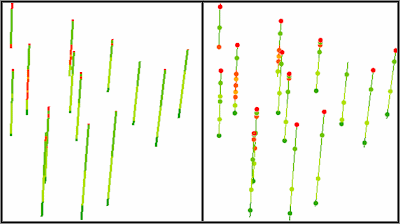
- Polylines: Choose this output style if you wish to see the data as polylines.
- Points (midpoint): Choose this output style to see the data as points. Compare the images below; the left image represents lithology data displayed as polylines in ArcScene. The right image represents lithology midpoints (on top of lithology polylines for reference).
-