RockWorks | Utilities | File | Import | WCS (Tobin Well Locations)
This program is used to import data from a Tobin Well Coordinate Service (WCS) file into the RockWorks datasheet. WCS files contain well location and other miscellaneous well information; you can select which fields to import.
Feature Level: RockWorks Basic and higher
Menu Options
Step-by-Step Summary
- Input File: Click here to browse for the Tobin WCS file to be imported.
- Items to Import: Click this tab to see an alphabetical listing of all of the well fields that can be imported. Insert a check in those to be imported; remove the check-mark from those to be skipped. For each, you can use the drop-down list specify the datasheet column name/number into which the data will be listed.
- Save Datasheet File: Check this box to assign a name to the datasheet file that will be created for the import. If you do not check this box, it will simply be displayed as Untitled.
- Output File Name:
- Automatic: Choose this to have the name of the file assigned automatically, using the name of the program plus a numbering digit.
- Manual: Choose this option to type a preferred name for the RwDat file into the prompt.
- Access the RockWorks Datasheet program tab.
- Create a new, blank datasheet using the File | New | Blank menu option.
- Choose the File | Import | WCS menu option.
- Enter the requested menu settings, described above.
- Click the Continue button to proceed.
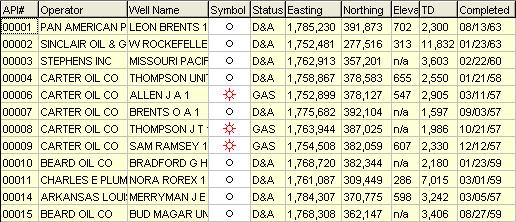
RockWorks will read the contents of the WCS file and list the wells in rows in the data window. The fields you requested will be listed in the data columns. Well symbol is selected based on a list of status definitions in a "Well Status Table."
- Update Project Dimensions: You will be prompted whether you want to establish or update the Project Dimensions based on the imported data. Be sure to do so at some point before generating maps.
- Once the well information has been imported, you can use the Maps | Point Symbols, Maps | Triangulation Contours, or Grid | Create | XYZ -> Grid programs to create a map of the well locations and/or contour map of the surface elevations.
 Back to Importing Data

RockWare home page