Click this tab to define the output format(s) for the exported data. You can select multiple options.
- RwDat (RockWorks): Check this option for the stratigraphy data to be exported to a RockWorks datasheet (.RwDat) format. (More info)
- CSV (Excel): Check this option for the stratigraphy data to be exported to a CSV file format for use in Excel. (More info)
- TXT (Notepad): Check this option for the stratigraphy data to be exported to a text (.txt) format. (More info)
- RTF (Word): Check this option for the stratigraphy data to be exported to an RTF file format for use in Word. (More info)
- SHP (ArcMap): Check this option for the stratigraphy data to be exported to a Shapefile format. Click on this tab to set up the Shapefile options.
- Output (Shape) File:: Click to the right to type in a name to assign the Shapefile to be created. The exporter will also create the accompanying .SHX and .DBF files.
- Null Value: If any of your borehole stratigraphy data are missing the depth to top or base for the interval, RockWorks will store a null value for that depth. Use this prompt to define the null value to be used, such as "-999".
- Output Type
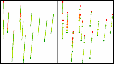
- Polylines: Choose this output style if you wish to see the data as polylines.
- Points (midpoint): Choose this output style to see the data as points. Compare the images below; the left image represents data displayed as polylines in ArcScene. The right image represents midpoints (on top of polylines for reference).
-