RockWorks | Utilities | Coords | Quick Locator
This program:
- Reads a single XY coordinate pair that you type into the program prompt. The point can represent any supported coordinate system.
- Creates a KML output file with this point location.
- Creates a KMZ (zip) output file, containing the KML file.
- Loads the KMZ file in Google Earth, if requested.
See also: Icon Maps for plotting multiple points in Google Earth.
Menu Options
Step-by-Step Summary
- Lon/Lat: Click this tab if the coordinates you wish to map in Google Earth represent longitude and latitude coordinates.
- Format: Select the format of your lon/lat coordinates by selecting it from the drop-down list. Refer to the examples displayed for each.
- Longitude: Type in the longitude coordinate for the point to be located, using the correct format as you selected. Western longitudes must be negative.
- Latitude: Type in the latitude coordinate for the point to be located. Southern latitudes must be negative.
- Local: Click this tab if the point to be mapped will be entered as local coordinates with a longitude and latitude reference point.
Note that the accuracy of placing local coordinates will diminish the further you are from the reference point.
- Local Coordinate System Origin: In order for these local coordinates to be referenced to the globe, you need to enter the longitude and latitude coordinates which are represented by the local system origin (0,0).
- Longitude: Type in the decimal longitude for the local origin. Be sure that western longitudes are negative.
- Latitude: Type in the decimal latitude for the local origin. Southern latitudes must be negative.
- Units: Choose whether these coordinates represent feet or meters.
- Easting: Enter here the local X coordinate of the point to be mapped.
- Northing: Enter the local Y coordinate of the point to be mapped.
- PLSS: Click this tab if the point to be displayed in Google Earth will be entered using Public Land Survey System descriptions.
! To map this type of coordinate, you need to be sure you've downloaded the RockWare LandBase first. See the LandBase topic for details.
- Meridian: Click on this button to select the meridian from the displayed map by clicking in the radio button.
- Range: Type in the Range number and select West or East.
- Township: Enter the Township number and select South or North.
- Section: Type in the Section number.
- Description: RockWorks support two different means of defining points within the specified Range, Township, and Section.
- Offset
- West - East: Enter the location as an offset from the section boundaries. Type in the offset distances in feet, and select the appropriate edge: FWL = feet from the West line; FEL = feet from the East line.
- South - North: Enter the location as an offset from the section boundaries. Type in the offset distances in feet, and select the appropriate edge: FNL = feet from the North line; FSL = feet from the South line.
- Quarter: Click on this option to enter the description in a quarter/quarter format. You can enter this a variety of ways:
"NW" or "SW", "SE/SE" or "W2/SE", "SE SE" or "W2 SE", "SE-SE" or "WW-SE", "SESE or "W2SE", "SE,SE" or "W2,SE", or similar. Use upper- or lower-case characters. You may use slash (/) characters, spaces, dashes, or commas within the description. You may also concatenate the descriptions (SESE).
- SPC: Click this tab if the point to be mapped will be entered in US State Plane coordinates in feet or meters.
- Zone: Click the large button to select the State Plane zone.
- Units: Choose whether these coordinates represent feet or meters.
- Easting: Enter here the State Plane X coordinate of the point to be mapped.
- Northing: Enter the State Plane Y coordinate of the point to be mapped.
- UTM: Click this tab if the point to be mapped will be entered in UTM (Universal Transverse Mercator) coordinates in feet or meters.
- Datum: Click this button to choose the Datum from the standard list. If your datum is not displayed here, use the Other coordinate option, discussed below.
- Zone: Click the large button to select the UTM zone.
- Units: Choose whether these coordinates represent feet or meters.
- Easting: Enter here the UTM X coordinate of the point to be mapped.
- Northing: Enter the UTM Y coordinate of the point to be mapped.
- Other: Click this button to choose a custom coordinate system. See Custom Coordinates for more information.
- Select the RockWorks | Utilities | Coords | Quick Locator menu option.
- Enter the X and Y coordinate for the point you wish to place in Google Earth, as described above.
- Click the Show Location in Google Earth button to continue.
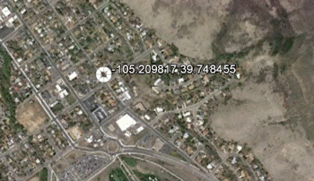
The program will create a KML file with the specified map location as a placemark. It will create a KMZ file that contains the KML file. The Google Earth KML and KMZ file names will be assigned automatically.
The resulting placemark will be displayed in Google Earth.
 Back to Coords Menu Summary
"Google" is a trademark of Google Inc.

RockWare home page