These data files, entered into the RockWorks datasheet, identify locations using bearing and distance (and optionally inclination) measurements. These can be translated to XYZ coordinates and/or illustrated as a 2D and/or 3D survey map (Survey menu).
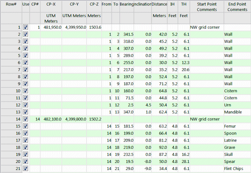
- Control Points: For stations to be used as control points, these are the required columns. There must be at least one control point declared in the datasheet in order for the program to compute survey station locations.
- Control point number: You must declare a station number for each control point in the listing. The program will use these numbers to identify each point.
- X-coordinate: Declares the X-coordinate or Easting for the control point. Be sure you define the coordinate system and units.
- Y-coordinate: Declares the Y-coordinate or Northing coordinate and units for the control point.
- Elevation: Declares the Z-coordinate or elevation and units for the control point.
- Description (optional): Declares any descriptions for the control point. There is a limit to 60 characters for this field.
- Survey Stations: For survey stations whose XYZ coordinates are not known and are to be computed by the program, the datasheet must contain these data:
- "From" station: Contains the starting station number from which the bearing, inclination and distance were measured. This must be either another survey station or a control point that is referenced somewhere in the spreadsheet.
- "To" station: Contains the ending station number to which the bearing, inclination, and distance were measured. This is the station number to assign to that sample point, and will be the station number listed in the output XYZ datasheet.
- Bearing: Declares the bearing in azimuth degrees from the starting station to the ending station, in degrees. Zero degrees represents north and bearings increase clockwise (0 - 359 degrees).
- Inclination: Declares the inclination from the starting station to the ending station, in degrees, where 0 degrees represents horizontal, positive degrees is upward and negative degrees is downward.
- Distance: Declares the distance from the starting station to the ending station. Please see UNITS, below.
- Instrument Height: Declares the height from the ground of the measurement instrument at the starting station. Be sure you define the coordinate system and units.
- Target Height: Declares the height from the ground of the target at the ending station, and units.
- Description: (Optional) Declares any descriptions for the survey station. There is a limit to 60 characters for this field.
- If there are survey stations that reference undeclared control points or other survey stations, the program will be unable to compute their XYZ coordinates.

RockWare home page