These files are used to build a 3D image containing disks at specific XYZ locations, each with a declared dip direction and angle, and with optional radius, size, and color declarations. This program requires 5 columns of information: The X Y Z (elevation) location of the disk centers, and dip direction and dip angle. Additional columns are optional.
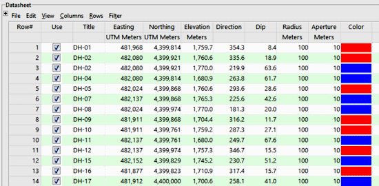
- Title (Optional): Identifies the sample.
- Easting (Required): Lists the X coordinates for the disk centers.
These can be Eastings in meters or feet, decimal longitudes, etc. See Defining your Datasheet Coordinates for more information.
- Northing (Required): Lists the Y coordinates for the points.
- Elevation (Required): Lists the elevation where the measurements were taken and where the disks should plot. Be sure you've defined the elevation units in the column heading.
- Dip Direction (Required): Direction, in degrees, that disc is dipping. North = 0, East = 90, South = 180, and West = 270. Note: This is the direction of maximum dip. It is NOT the "strike".
- Dip Angle (Required): Note: Horizontal is considered to be zero. Dipping straight down is considered to be 90.
- Radius (Optional): The radius of each disc may be independently controlled via this data column. Be sure you've defined the radius units in the column heading. If you don't list the radius values in the datasheet, you can plot the disks using a fixed radius which is defined in the options menu.
- Aperture (Optional): The aperture or thickness of each disc may be independently controlled via this data column. Be sure you've defined the thickness units in the column heading. If you don't list the aperture values in the datasheet, you can plot the disks using a fixed thickness which is defined in the options menu.
- Color (Optional): The color of each disc may be independently controlled via this data column. If you don't list the colors in the datasheet, you can select a fixed color in the options menu for all of the disks.
- Planes_StrikeDip_3D.rwDat

RockWare home page