
RockWorks | Utilities | Planes | 3-Points->Planes | Single
This program will compute the slope angle and direction of the triangle formed by the three input points. It will create a simple map illustrating the dip with contour lines, and will include the selected control point and dip statistical annotations as specified. The completed 3-point contour map will be displayed in RockPlot2D.
Note: The program assumes that the points you enter are in the units and coordinate system established for your Output Dimensions.
Menu Options
Step-by-Step Summary
Menu Options
- Point #1: Expand this heading if necessary to type in the X, Y, and Z coordinates for the first known point.
- X: Click on this item to type in the X (Easting) coordinate for the first known point.
- Y: Click on this item to type in the Y (Northing) coordinate for the first known point.
- Z: Click on this item to type in the Z (elevation) value for the first known point.
- Point #2: Expand this heading if necessary to type in the X, Y, and Z coordinates for the second known point.
- X: Click on this item to type in the X (Easting) coordinate for the second known point.
- Y: Click on this item to type in the Y (Northing) coordinate for the second known point.
- Z: Click on this item to type in the Z (elevation) value for the second known point.
- Point #3: Expand this heading if necessary to type in the X, Y, and Z coordinates for the third known point.
- X: Click on this item to type in the X (Easting) coordinate for the third known point.
- Y: Click on this item to type in the Y (Northing) coordinate for the third known point.
- Z: Click on this item to type in the Z (elevation) value for the third known point.
- Contour Interval: Click on the Contour Interval item to enter the interval, in elevation units, at which contour lines should be drawn.

-
Labeled Contour Interval: Click on the Labeling Interval item to enter the interval, in consistent elevation units, at which contour lines should be labeled. This must be an even multiple of the Contour Interval.
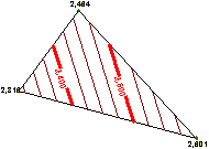
- Plot Elevations: Insert a check in the Plot Elevations check-box to label the control points with their elevation values.
- Plot Statistics: Insert a check in the Plot Statistics check-box to include the computed strike and dip directions, and the dip angle with the output map.

Step-by-Step Summary
- Access the Utilities program tab.
- Select the Utilities | Planes | 3-Points->Planes | Single program.
- Enter the input points and menu options as described above.
- Click the Process button to continue.
The program will read the coordinates and settings from the options window, compute the strike and dip of the plane that passes through the three input points, and create a simple contour plot. The completed map will be displayed in a RockPlot2D tab in the Options window.
- You can adjust any of the settings in the Options window (diagram settings, etc.) and then click the Process button again to regenerate the map.
! Each time you click the Process button, the existing display will be replaced.
- View / save / manipulate / export / print the map in the RockPlot2D window.
 Back to Planes Menu Summary

RockWare home page